The Mohawk Trail
Driving the Mohawk Trail
Running east from North Adams toward Greenfield and I-91, and taking its name from the warpath used for raids against Algonquin settlements along the upper Connecticut River Valley, the Mohawk Trail (Route 2) was one of the nation’s first scenic highways, improved and paved as early as 1914 as part of a massive state effort to lure tourists into this cash-deprived farm belt of New England. If you’re driving an overloaded or underpowered vehicle, you’ll appreciate the thrill and radiator-popping risks that once attended the slow switchback grind up around the attention-getting Hairpin Turn at the edge of the Western Summit. The turn is so tight that signs insist on a 15-mph (24 km/h) speed limit, and people who don’t abide by the rules are likely to find themselves screeching around past the sightseers at the friendly Golden Eagle Restaurant (1935 Mohawk Trail, 413/663-9834).
Farther up, at the top of the hill, the tidy Whitcomb Summit Retreat (413/664-0007, $109 and up) is in the best shape of the many photogenic old motor courts along this route. It has been taking in guests since 1914. One of the original cottages has been left untouched, but the rest of the resort has been fully modernized.
Don’t be fooled by the short stretch of gentle ups and downs east of the summit over the glacier-flattened mountain peaks: The route east along the tortuous Cold River ravine quickens the pulse, even in these days of power steering and antilock brakes, especially if you get sandwiched between a pair of 18-wheelers, whose burning brake pads sometimes scent the air all the way down the valley.
East of the summit, dropping down into the valley of the Deerfield River, you pass groups of kayakers and some roadside stands offering rentals of inner tubes—the white-water equivalent of a recliner, and the preferred mode of transport for those interested in relaxing and enjoying the ride. More serious river runners may want to sign up for one of the trips offered by Zoar Outdoor (800/532-7483), who also welcome travelers with a range of cabins, yurts, and camping options.
The Mohawk Trail area is also home to some enticingly kitschy old “Indian Trading Post”-style tourist attractions and souvenir shops, all packed full of postcards, plastic tomahawks, and moccasins; my personal favorite is the Native Views, formerly known as the Big Indian Shop because it’s fronted by a historically inaccurate, politically incorrect, and photogenically irresistible 35-ft-tall (11-m) statue of a Plains man. Another giant Native American statue, a half-ton bronze titled Hail to the Sunrise, stands along Route 2 just west of the town of Charlemont.
You’ll find excellent wooded hiking trails and streamside campsites in Mohawk Trail State Forest (413/339-5504), just above where the Cold River empties into Deerfield. There are six year-round rustic log cabins too, but make reservations well in advance if you have your heart set on staying in one.
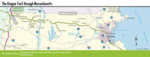
Map of the Oregon Trail Route in Massachusetts
Related Travel Guides