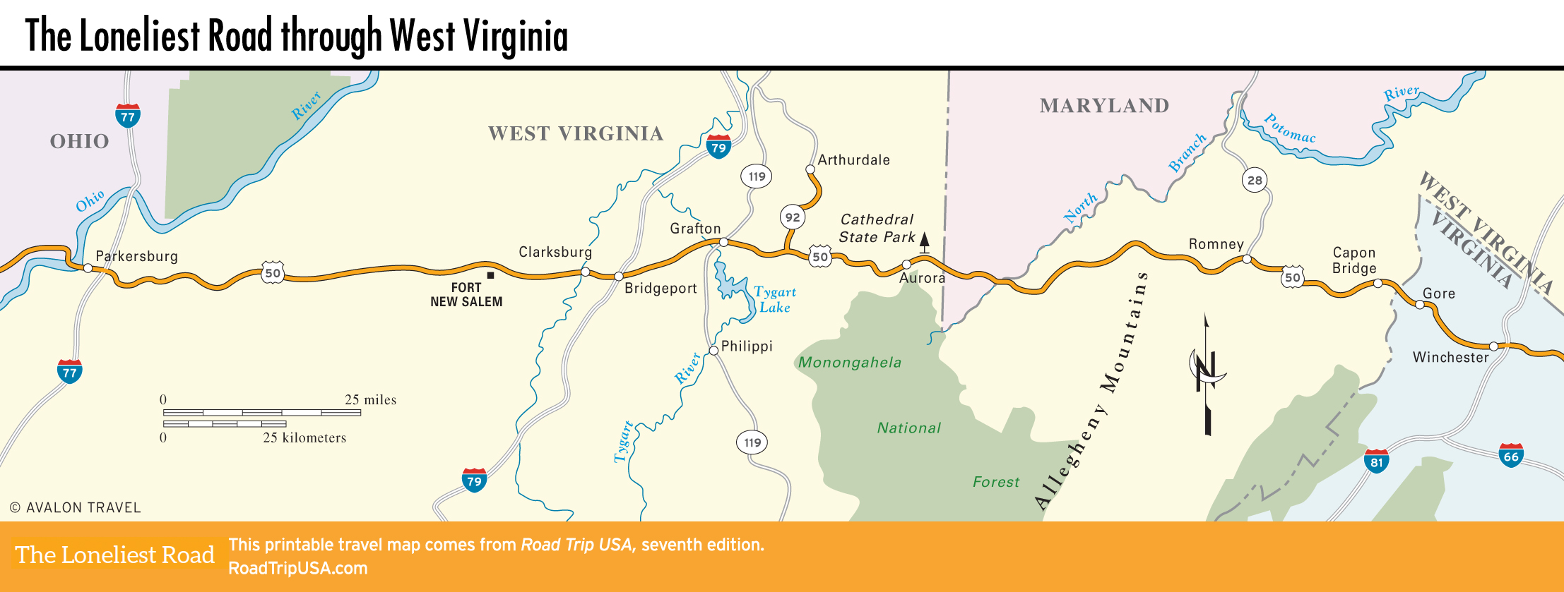
Parkersburg to Grafton
Parkersburg
Northern West Virginia’s largest and most heavily industrialized city, Parkersburg (pop. 29,675) is located strategically at the junction of the Ohio and Little Kanawha Rivers. The town’s economy is based on an unusual pair of employers: the federal Bureau of the Fiscal Service, which redeems U.S. Savings Bonds, and a massive DuPont Teflon factory.
Though the first impression can be fairly bleak, Parkersburg does merit a closer look. The Blennerhassett Museum of Regional History (304/420-4800, Tues.-Sun., $4), housed in a turn-of-the-20th-century brick warehouse at 2nd and Juliana Streets, traces regional history, with a focus on the escapades of the Irish aristocrat Harman Blennerhassett, who in 1806 conspired with Aaron Burr to establish an independent fiefdom in Texas and the Southwest. If you’re interested, you can ride a sternwheeler to and from the Ohio River island on which Blennerhassett built the palatial home where the plot was hatched. The house has been reconstructed as a state park (tours $5). Boats ($10) leave hourly for the island from Point Park, which is two blocks west of the museum, under the railroad bridges and on the far side of the 25-ft (8-m) concrete flood walls at the confluence of the rivers.
Parkersburg also has a good range of motels and a couple of coffee shops along US-50 on the east side of town. Stay overnight at the delightful Blennerhassett Hotel (320 Market St., 304/422-3131 or 800/262-2536, $99 and up).
Fort New Salem
Between Parkersburg and Clarksburg, US-50 winds along as a fast four-lane freeway through a mountainous onetime oil- and gas-producing region dotted with tiny all-but-forgotten towns. The small farms are cultivated by descendants of Scotch-Irish immigrants who settled here in the late 18th century. One place that’s well worth a short stop is Fort New Salem (304/695-2220, $5), which is 14 mi (22.5 km) west of Clarksburg. Just south of US-50, near the campus of Salem International University, the fort consists of 18 historic log cabins relocated here in the 1970s.
Clarksburg
Clarksburg (pop. 15,480) is a tidy railroad town sitting on the West Fork River. The downtown area is a sampler of turn-of-the-20th-century commercial buildings, great for taking pictures of old signs and brick walls. It’s also the birthplace of Confederate general Thomas “Stonewall” Jackson, commemorated by a plaque on the house where he was born, at 326 Main Street.
The town’s large Italian population, estimated at around 40 percent, supports numerous good restaurants, like Minard’s Spaghetti Inn (813 E. Pike St., 304/623-1711) on old US-50, at the Joyce Street exit off the US-50 freeway. Another good old-fashioned place to eat is the Ritzy Lunch (456 W. Pike St., 304/622-3600), selling famous chili dogs since 1933.
On the east side of Clarksburg, US-50 climbs a steep hill before becoming suddenly busy at Bridgeport, which straddles the I-79 freeway, around which the highway is lined by a 2-mi (3.2-km) sprawl of motels and fast food.
Grafton: International Mother’s Day Shrine
Grafton (pop. 5,040), the first large town west of Winchester, Virginia, grew up as a bustling B&O railroad town beginning in the 1850s but is now among the most economically and socially depressed places in the state. Dozens of architecturally interesting but run-down houses and churches on brick-paved streets descend the steep hills to the Tygart River and the railroad tracks, where a monumental station and a grand but boarded-up hotel are grim reminders of Grafton’s formerly busy self.
Besides its physical setting, Grafton’s main claim to fame is as the birthplace of Mother’s Day, first celebrated here in 1908 in a Methodist church that’s now been converted into the International Mother’s Day Shrine (11 E. Main St., 304/265-1589, call for hours or to schedule a tour, $5), across from the old train station.
East of Grafton, the landscape becomes more mountainous, and isolated villages replace the small towns that line the western half of the route.
Related Travel Guides