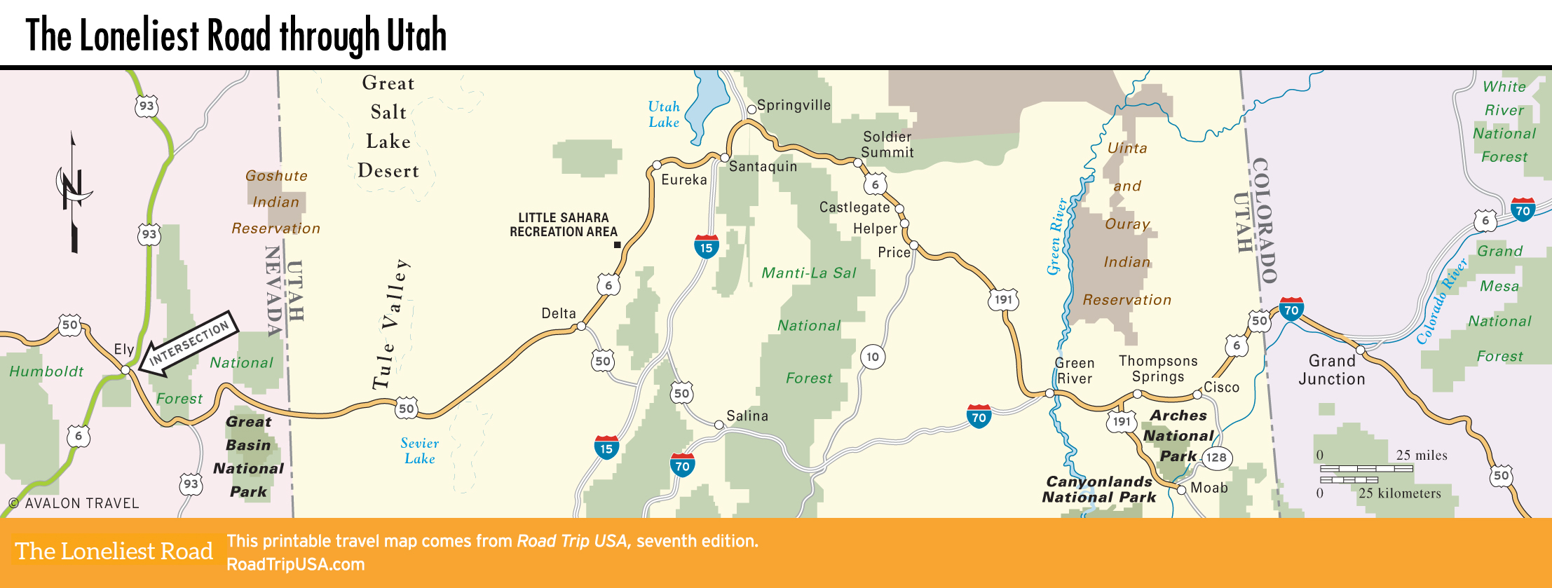
Delta to Eureka
Delta
The striking silhouette of North Peak rises above US-50 about 85 mi (137 km) east of the Nevada border, as the landscape changes suddenly from sagebrush desert to lush pastures around the town of Delta, which is irrigated by the green Sevier River. Delta bills itself the “Gateway to Great Basin National Park,” and it does have a Days Inn and other motels, gas stations, and grocery stores—but little else to attract visitors. One place worth a stop is the small Great Basin Museum (45 W. Main St., 435/864-5013, Mon.-Sat. summer, Thurs.-Sat. winter, donation), which features minerals, arrowheads, and local history exhibits. Next door, the Topaz Museum (435/864-2514) includes a thoughtful display of artifacts relating to Topaz Camp, a World War II internment camp set up in the desert 16 mi (26 km) northwest of Delta by the U.S. government to imprison more than 8,000 American men, women, and children of Japanese descent.
From Delta, US-50 officially cuts southeast across I-15, linking up with I-70 at Salina for the trip east to Grand Junction. Our route, however, follows US-6 (old US-50) toward the Great Salt Lake area, then east over the Wasatch Front, rejoining official US-50 (now I-70) at Green River.
Little Sahara Recreation Area
From Delta, the route follows the Sevier River northwest, racing across the featureless desert for 32 mi (52 km) before reaching the well-posted turnoff north to the Little Sahara Recreation Area. Visible from the highway, to the north of US-6, the Little Sahara Recreation Area holds 60,000 ac (24,280 ha) of sand dunes and sagebrush flats, the prettiest parts of which are preserved for hikers and campers, though motorcyclists and ATVers can overwhelm any sense of peace and tranquility, turning it into a campground from hell.
Eureka
The weather-beaten town of Eureka (pop. 695), 50 mi (81 km) east of Delta and 20 mi (32 km) west of the I-15 freeway, climbs steeply up surrounding mountainsides at the heart of the once-thriving Tintic Mining District. As recently as the 1930s, thousands of miners dug millions of dollars’ worth of gold, silver, copper, and lead out of the ground every year. Now the massive wooden head-frames of long-closed mine shafts stand high above the houses and prefab trailers that cling to the slopes, while fading signs advertise abandoned businesses along Main Street.
Though diehard residents still speak of plans to reopen one or more of the mines, prosperity seems a distant dream in Eureka, and while it’s not quite a ghost town, it seems well on its way there. The glory days are recounted in the small Tintic Mining Museum (435/433-6842), next to City Hall on Main Street. At the west edge of town a historical plaque stands alongside the heavy timber head-frame of the Bullion-Beck Mine, one of the area’s most productive.
Heading east from Eureka, our route bends across rock-strewn sagebrush hills around the southern shore of Utah Lake toward I-15. Utah Lake, which is freshwater in contrast to the briny expanse of the Great Salt Lake to the north, used to be much larger than it is now, before so much of it was diverted to water the apple, peach, and cherry orchards that line US-6 around Santaquin—with gas stations as a reliable source of fuel for westbound travelers heading to Delta, 70 mi (113 km) to the southwest. From Santaquin, follow the I-15 freeway north to Springville, from where the Salt Lake City megalopolis stretches north along I-15 for nearly 100 mi (161 km).
Related Travel Guides