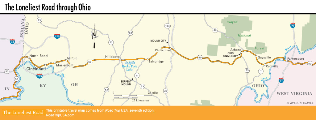
Chillicothe to Athens
Chillicothe and Mound City
In the middle of the state, Chillicothe (pop. 21,698; pronounced “chill-a-COTH-ee”) comes as a sudden surprise after the pastoral landscape that surrounds it. It is one of the state’s oldest industrial centers; since 1812 Chillicothe’s economy has revolved around the massive paper mill on the south side of town, which has a red-and-white striped smokestack that belches a pungently steaming white cloud around the clock.
Heavy industry aside, Chillicothe has done an admirable job of preserving its history, most notably in the recently spruced-up “First Capital” district along Main Street (US-50) downtown. Dozens of elaborate late-Victorian commercial buildings and Greek Revival-style mansions, mostly dating from the mid-1850s, surround the overwrought Ross County Courthouse, which has a different entrance for each government department.
While the downtown area is worth a quick stroll, specific sights are few, and the area’s real attraction is 3 mi (4.8 km) north of town via Hwy-104. Officially known as the Hopewell Culture National Historical Park, but usually called Mound City, this complex of prehistoric burial sites sits on the west bank of the Scioto River, just beyond a huge prison complex. Some two dozen distinct, grass-covered mounds, the largest of which is about 17.5 ft (5 m) high, are reachable on a mile-long (1.6-km) trail that starts at the visitors center (16062 Hwy-104, 740/774-1126, daily, free), where films and exhibits explore aspects of this 2,000-year-old culture.
Chillicothe is known throughout Ohio as the site of Tecumseh (740/775-0700 or 866/775-0700, Mon.-Sat. 8pm summer, $30), an outdoor pageant dramatizing the life of the Shawnee warrior.
Athens
East of Chillicothe, US-50 passes through Vinton County, one of the state’s poorest and least-developed regions. Hidden amid forested hills, the remains of coal mines and overgrown rail-fenced cornfields line the next 50 mi (81 km), and little has changed (for the better, at least) since the WPA Guide to Ohio described the scene in 1939: “Abruptly the road sweeps into a rock-bound gorge dotted with the rickety houses of hill-folk…who make a living by seasonal mining, moonshining, trapping, or on Government relief projects.”
After all this rural poverty, US-50 finally arrives at Athens (Ppop. 24,688), one of the most attractive small towns in Ohio. Set, like its classical namesake, on a series of hills, Athens is an idyllic little town that has grown up around the leafy campus of Ohio University, which opened here in 1809. It’s a pretty place, with brick-paved streets, bookstores, copy shops, and clothing stores filling the eight-block Uptown neighborhood along College and Court Streets on the north side of the neoclassical college green.
US-50 follows the Hocking River and bypasses the heart of town, so follow Stimson Avenue or State Street from the highway, past the cafés and shops that fill the few blocks around the campus, where the Union Street Diner (70 W. Union St., 740/594-6007) has Athens’s best cheap burgers and sandwiches. A cone or cup of Whit’s Frozen Custard (49 S. Court St., 740/594-7375) will help you cool down on a hot summer’s day. Accommodations in Athens include a Hampton Inn (986 E. State St., 740/593-5600), just east of campus, and many other motels along Columbus Road on the north side of town.
East of the Athens area, US-50 passes through 40 mi (64 km) of scrubby second-growth forests and the abandoned but enticingly named coal-mining towns of Guysville and Coolville, before reaching the West Virginia border at the Ohio River and Parkersburg.
Related Travel Guides