Austin to Eureka
Austin
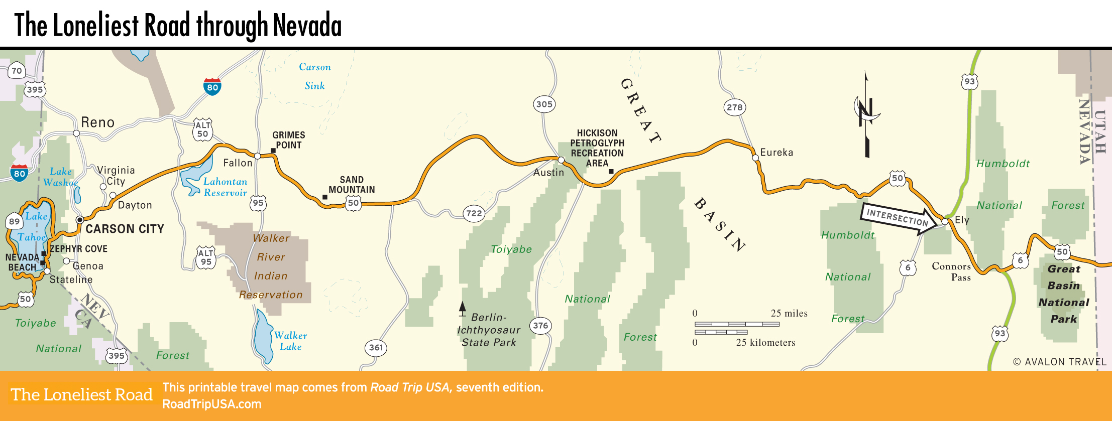
Some 110 mi (177 km) east of Fallon and 70 mi (113 km) west of Eureka, tiny Austin (pop. 113) huddles well above 6,000 ft (1,829 m) on the north slope of the mighty Toiyabe Mountains. The steep incline of Main Street (US-50) as it passes through town attests to the precariousness with which Austin has clung to life since its 10-year mining boom ended—in 1873. Austin hangs on to the rustic, steadfastly unwhitewashed nature that was once—and in some places, remains—central to Nevada’s character. Austin takes its central assignment seriously, since the state’s exact geographical center is a mere 12 mi (19.3 km) to the south (near the hard-to-find but pleasant Spencer Hot Springs).
According to local legend, a Pony Express rider accidentally discovered silver ore here in 1862, and the rush was on. Prospectors fanned out from Austin, which was named after the Texas hometown of one of its founders, to establish Belmont, Berlin, Grantsville, Ione, and dozens of other boomtowns-turned-ghost towns; roughly $50 million in gold and silver was shipped out over the next 10 years. Since then Austin has experienced a long, melancholy decline, though recent efforts to mine the abundant turquoise in the region have met with some success.
A two-minute drive (at 10 mph/16 km/h) along Main Street takes you past all there is to see in Austin today, but you could easily spend hours wandering around the place or hanging out in its quirkily populated junk shops, cafés, and bars. The impressive steeples of the Roman Catholic, Methodist, and Episcopal churches dominate the townscape, while at the western (downhill) end of town you can glimpse Stokes Castle, a three-story stone sentinel built in 1897 and lived in for all of a month. It looks best from a distance, looming over the nearby cemeteries, but if you want to get closer, follow Castle Road for about a half-mile south from US-50.
For its 100 or so residents, Austin has two gas stations (it’s a long way to the next town, so fill up here) and three motels—including the clean but basic mobile home trailers of the Cozy Mountain Motel (40 Main St., 775/964-2471, $66 and up). Two cafés are right on US-50/Main Street: the ancient International Café and Bar, moved here board by board from Virginia City in 1863, and the Toiyabe Café.
Get a great feel for Great Basin life by spending some time at Miles End Ranch B&B (107 Del Dr., 775/964-1046), about 30 mi (48 km) south and east of Austin via Hwy-376, with a wood-fired hot tub and all the stars you can ever want to see.
Hickison Petroglyph Recreation Area
Bookended by 7,000-ft (2,134-m) mountain ranges at either end, the route between Austin and Eureka is perhaps the longest, flattest, straightest stretch of the entire trans-Nevada length of US-50—over 70 mi (113 km) of Great Basin nothingness. Cattle ranches fill the plains, which were crisscrossed by early explorers like John C. Fremont, who passed through in 1845, as well as by the Pony Express and the Butterfield Stage. Such recent history, however, pales in comparison to the relics from the region’s prehistoric past, particularly the fine petroglyphs carved into the rocks on the eastern side of 6,594-ft (2,010-m) Hickison Summit, 24 mi (39 km) east of Austin and 46 mi (74 km) west of Eureka.
Now protected as part of the BLM-operated Hickison Petroglyph Recreation Area, the petroglyphs stand in a shallow sandstone draw on the north side of the highway. A half-mile (0.8 km) trail loops through sagebrush, junipers, and piñon pines from the parking area and campground past dozens of these enigmatic figures, some of which are thought to date back as far as 10,000 BC. Somewhat surprisingly, so far they are graffiti-free.
Eureka
Right in the middle of a 100-mi (161-km) stretch of spectacular Great Basin scenery, Eureka is one of the most engaging and enjoyable stops in the state. Unlike a lot of places along the Loneliest Road, Eureka is fairly thriving, thanks to numerous gold mines still in operation in Eureka County.
The four blocks of 100-year-old buildings lining the steeply sloping, franchise-free Main Street (US-50) are a mix of well-restored brick and wood storefronts alongside less fortunate ruins, some merely sets of cast-iron pilasters holding up false fronts. The focal point, the grand 1879 Eureka County Courthouse, is still in use. Behind it, the Eureka Sentinel Museum (775/237-5010, Tues.-Sat., free) has displays tracing the lively local history as well as typesetting equipment and printing presses of the newspaper published here from 1879 to 1960.
Besides being an intriguing place to stroll around (walking-tour booklets are available from the Sentinel Museum and many local shops), Eureka is also a good place to break a journey. The Eureka Gold Country Inn (775/237-5247, $107 and up) has modern rooms and is conveniently located on Main Street. Good food and drink can be had at DJ’s Diner & Drive In (501 S. Main St., 775/237-5389) and from the Owl Club Bar & Steakhouse (61 N. Main St., 775/237-5280), which has been in business forever.
Related Travel Guides