Annapolis
Visiting Annapolis
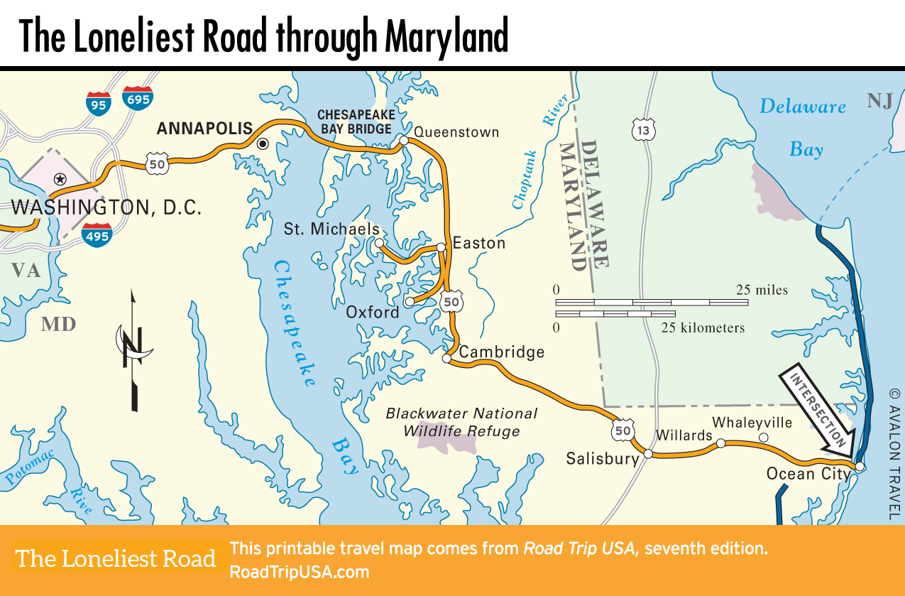
One of the most attractive and well-preserved historic cities in the United States, Annapolis (pop. 39,174) was first settled in 1649 and chartered in 1708. Briefly the young nation’s capital from November 1783 to June 1784, it is today Maryland’s state capital, best known for its maritime heritage, both as a yachting center and as home of the U.S. Naval Academy, which stands guard along the Chesapeake Bay waterfront.
The historic center of Annapolis is just south of US-50 via Hwy-70, which leads straight to the State House (daily, free), where the U.S. Congress met in 1783-1784 and ratified the Treaty of Paris, ending the Revolutionary War. The west facade is fronted by a memorial to Supreme Court Justice Thurgood Marshall. From the State House, Main Street drops downhill to the City Dock waterfront, where a visitors center has walking-tour maps and guides to the wealth of historic buildings, including the beautiful colonial-era Hammond-Harwood House (19 Maryland Ave., 410/263-4683, Wed.-Mon. Apr.-Dec., $10).
Annapolis has a number of good places to eat, including the venerable Chick & Ruth’s Delly (165 Main St., 410/269-6737), and Iron Rooster (12 Market Space, 410/990-1600), a popular breakfast, lunch, and brunch place near the waterfront, and the fancy yachts moored along “Ego Alley.”
To fully absorb the colonial-era ambience, stay a night or two at the Historic Inns of Annapolis (410/263-2641 or 800/847-8882, $80 and up), a trio of historic homes right across from the State House, or any of the town’s many characterful B&Bs.
Chesapeake Bay Bridge
Before the 4-mi-long (6.4-km) Bay Bridge was completed in the early 1950s, Maryland’s Eastern Shore was physically and spiritually an island, protected by the broad Chesapeake Bay from the sprawling modern cities of Washington and Baltimore, and cut off at its neck by the Chesapeake and Delaware Canal. Despite the completion of a parallel span in the 1970s, the bridge gets clogged solid each summer by vehicles headed for coastal resorts like Rehoboth Beach (“The Beltway by the Bay”) and Ocean City.
At the west end of the bridge, US-50 lands at Sandy Point State Park, where you can swim, hike, or launch a boat. At the eastern end, US-50 is joined by US-301, and together the two roads race along as a six-lane freeway as far as Queenstown, a busy port in the early 1800s but now little more than an upscale suburb of the greater Baltimore-Washington urban area.
Related Travel Guides