Vallejo, Fairfield, Vacaville
On the north side of the Carquinez Straits, through which the Sacramento and San Joaquin Rivers flow into San Francisco Bay, Vallejo is a blue-collar maritime town that made national news by declaring bankruptcy in 2008, in the wake of the subprime housing crash. Longtime home of the huge and historic Mare Island Naval Shipyard, which, from 1854 to 1994, built and maintained many of the country’s fighting ships and submarines, Vallejo also served as California’s state capital on two different occasions in the gold rush years of the early 1850s. These days, Vallejo’s one bona fide attraction is the theme park Six Flags Discovery Kingdom (707/644-4000, hours vary, daily summer, around $73), on the north side of town just west of I-80. Along with one of California’s most intense arrays of high-speed thrill rides (like 65-mph/105 km/h Medusa, or the even-faster The Flash: Vertical Velocity), Six Flags is surrounded by more than 135 ac (55 ha) of kid-friendly animal attractions, so you can admire tigers, elephants, and dolphins, or feed the tropical birds and butterflies.
Between the San Francisco Bay Area and Sacramento, I-80 passes through an ever more suburbanized corridor, where towns like Fairfield and Vacaville have grown almost exponentially, from a few hundred residents in the 1950s to more than 100,000 today. Fairfield (pop. 116,884) grew up around busy Travis Air Force Base, and more enjoyably is also home to the Jelly Belly Jelly Bean Factory (800/522-3267 or 800/953-5592, self-guided tours daily, free).
From the coastal hills the landscape flattens out into the endless plain of the Sacramento Delta, and 80-mph (129 km/h) I-80 crosses an unstintingly flat landscape of farmland, housing tracts, and big-box shopping centers. Just before Sacramento, I-80 reaches bike-friendly Davis, a former Lincoln Highway town that’s home to a University of California campus, renowned for its winemaking school and creative fine art faculty, including pop art legend Wayne Thiebaud, celebrated in the stunning Manetti Shrem Museum of Art (254 Old Davis Rd.).
East of Davis, I-80 is raised on stilts across the Yolo Bypass wetlands, one of the last signs of the natural delta that covered this part of California before the water supply was diverted to other parts of California.
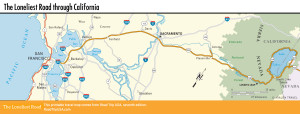
Map of the Loneliest Road through California
Related Travel Guides