Gold Country
California Gold Country: Placerville and Coloma
The main US-50 stop in the Sierra Nevada foothills, Placerville (pop. 11,048; elev. 1,867 ft/569 m) takes its name from the placer gold deposits recovered from the South Fork of the American River, which flows just north of town. The historic core of Placerville is well preserved, with a few cafés and bars paying homage to its rough-and-tumble past. A reminder of the town’s gold-rush heritage is the nation’s only municipally owned gold mine: Gold Bug Park and Mine (530/642-5207, daily summer, Sat.-Sun. fall-spring, $9), a mile (1.6 km) north of US-50 off the Bedford Avenue exit. A stamp mill and other mining equipment stand outside the entrance to the mine tunnel, which you can explore on a self-guided tour.
If you want to explore the region’s many evocative gold rush-era remnants, Placerville makes a good base, with its handful of motels (including a Best Western and a Days Inn) fronting the highway. Placerville also has the Old Town Grill (444 Main St., 530/622-2631), serving up world-class shoestring french fries along with burgers and refreshing milkshakes.
North and south of Placerville, Hwy-49 runs along the Sierra Nevada foothills through the heart of the Gold Country. Starting in the north beyond beautiful Nevada City, Hwy-49 winds through one historic town after another, all the way to the gates of Yosemite National Park, around 150 mi (242 km) to the south. One great old Gold Country haunt can be reached within a short drive of US-50 from Placerville. The ancient and still popular Poor Red’s Bar-B-Q (530/622-2901), housed in a gold-rush-era stagecoach station in the hamlet of El Dorado, 5 mi (8 km) south of Placerville on Hwy-49, has full lunches and dinners (and great margaritas) for little money.
If you have the time and inclination to take a longer detour, head south along Hwy-49 to the stately town of Sutter Creek, then climb up into the mountains via winding Hwy-88, which passes by the intriguing semi-ghost town of Volcano before linking up again with US-50 near Lake Tahoe and Carson City.
North of Placerville via Hwy-49, the original site of the discovery of gold, Sutter’s Mill, has been reconstructed as part of Marshall Gold Discovery State Historic Park (530/622-3470, daily, $8 per car) in Coloma, now an idyllic place along the banks of the American River, 9 mi (14.5 km) north of Placerville along Hwy-49. The 274-ac (111-ha) park, set aside in 1890 as the state’s first historic monument, is also a prime spot for white-water rafting and kayaking, especially on weekends, so don’t be surprised to find the place thronged with wet-suited and Teva-shod hordes.
The American River and Lover’s Leap
Some 20 mi (32 km) east of Placerville, US-50 changes suddenly from a four-lane freeway into a twisting, narrow, two-lane road over the crest of the Sierra Nevada. The usually busy highway, which every year is battered and frequently closed by winter storms, runs right alongside the steep banks of the American River. The lushness of the western Sierra Nevada is immediately apparent as the road passes luxuriant groves of pine, fir, and cedar, with numerous old resorts and vacation cabins lining the highway.
About 6 mi (9.6 km) west of the summit, the towering granite cliff of Lover’s Leap stands out to the south of the highway, its 600-ft (183-m) face attracting rock climbers, while to the north the delicate cascade of Horsetail Falls offers a more serene pit stop. Climbing east up US-50’s steepest set of hairpin turns, you’ll reach 7,365-ft (2,245-m) Echo Summit, which gives great views of the Lake Tahoe basin—the shining blue waters beckoning you along another steep stretch of US-50, downhill to the lakeshore itself.
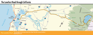
Map of the Loneliest Road through California
Related Travel Guides