Jonesboro and Cape Girardeau
Jonesboro
Just under 50 mi (81 km) south of Chester, 8 mi (12.8 km) east of the GRR via Hwy-146, the small town of Jonesboro hosted the third of seven 1858 U.S. Senate campaign debates between challenger Abe Lincoln and incumbent Stephen Douglas, who tried to portray Lincoln as being out of touch with the people over the issue of slavery. Although Illinois was a designated free state, this area had strong sympathies with the South, something it maintains to this day.
Broad Street, a.k.a. Hwy-146, roughly marks the route of the Trail of Tears, the 1838 winter death march of the Cherokee Nation from their homeland west to reservations in Oklahoma.
If you’re looking for a meal while passing through Jonesboro, Dixie Barbecue (205 W. Broad St., 618/833-6437) is a good option.
Back on Hwy-3, just north of I-57 and the town of Cairo, the GRR passes Horseshoe Lake Conservation Area, an example of what happens when the river shifts to a new channel and leaves an oxbow lake behind. Now prime winter habitat for more than a million migrating geese and ducks, its tupelo gum trees, bald cypress, and swamp cottonwoods foreshadow the scenery found downstream among the bayous of the Mississippi Delta.
Cape Girardeau
If you don’t have time to follow the GRR’s leisurely wind across southern Illinois, the fastest routes between St. Louis and Memphis are west of the Mississippi, where both US-61 and high-speed I-55 make quick work of the 295-mi (475-km) drive. Along with Sainte Genevieve, another good stop on the Missouri side is the city of Cape Girardeau (pop. 39,853), the biggest and most bustling place for miles. Boyhood hometown of right-wing radio talk-show host Rush Limbaugh, whose father and grandfather were both local lawyers, Cape Girardeau dates its founding back to its days as trading post in the early 1700s, when the area was still in the hands of the French. The long history of the town and surrounding region is engagingly portrayed in a 1,100 ft-long (335-m-long) series of large murals (24 different scenes, totaling nearly 18,000 sq ft (1,672 m), painted on the massive concrete flood walls that protect downtown from Mississippi floods.
You can take in some of the murals, and the whole Cape Girardeau experience, while enjoying a meal at Port Cape restaurant (19 N. Water St., 573/334-0954), while more memorable food is on the menu at Broussard’s Cajun Cuisine (114 N. Main St., 573/334-7235), a block away.
One of many scenes portrayed in the Cape Girardeau murals is a truly tragic one. Six years after wiping out the Native Americans of the upper Mississippi in the Black Hawk War, President Andrew Jackson ordered the “Five Civilized Tribes” of the Cherokee, along with all Native Americans across the southeastern United States, to be forcibly removed from their fertile lands in Florida, Georgia, and Tennessee, where gold had just been discovered. Some 5,000 Cherokee people died along this 1,000-mi (1,609-km) journey, during which many of the men, women, and children crossed the Mississippi River here at Cape Girardeau. The 3,400-ac (1,376-ha) Trail of Tears State Park (573/290-5268), 10 mi (16 km) north of town, preserves the scene of one moment along this marathon tragedy, with a 2-mi (3.2-km) section of the historic trail and interpretive plaques marking the wooded riverside bluffs.
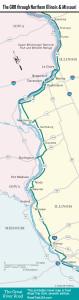
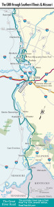
Travel Maps of the Great River Road
Related Travel Guides