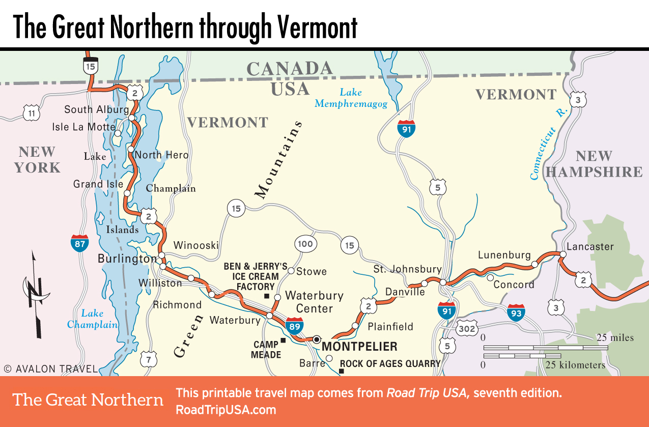
Lake Champlain Islands
After its brief jaunt across New York from the Canadian border, US-2 winds across the sleepy Lake Champlain Islands. Pancake-flat and covered with cows, orchards, and pick-your-own fruit farms, this trio of islands is pretty to drive across, with the Adirondacks rising up to the west and the Green Mountains to the south and east, but there’s not a lot to do; far more farm animals than people populate the route, and tractors clog the road, flinging clods of mud and manure (here pronounced “man-OO-ah”) with abandon.
From the middle of the Alburgh Peninsula, where US-2 crosses from New York into Vermont, a turn west onto Route 129 leads to Isle La Motte, home of the first French settlement in Vermont, established in 1666. The site is now occupied by Saint Anne’s Shrine, a popular pilgrimage destination featuring daily outdoor masses in summer and a granite statue of the explorer Samuel de Champlain, for whom the lake is named.
Continuing south on US-2, the town of North Hero (pop. 794) has a gas station, a stone courthouse, a number of quietly luxurious vacation homes dating from the early decades of the 20th century, and the handy Hero’s Welcome, a café and general store at the center of the two-block-long town. A mile south along US-2, Shore Acres Inn and Restaurant (802/372-8722, $138 and up) offers tennis courts, boating and swimming, moderately priced lakeside rooms, and a restaurant.
The town of Grand Isle (pop. 2,057), 8 mi (12.8 km) and another bridge to the south, ambitiously claims to be “The Beauty Spot of Vermont.” A well-marked turn leads to tiny Grand Isle State Park (802/372-4300), on the shores of the lake, where there’s a nice campground. At the other end of the island, connected by a causeway to the mainland, South Hero is another quaint little place; it and North Hero were named after those famous Vermont Revolutionary War heroes, the Green Mountain Boys, Ira and Ethan Allen.
From South Hero, US-2 rejoins the mainland at the entrance to Sand Bar State Park, set in a forest with picnic tables and bathing beaches, surrounded by sprawling, wildfowl-rich marshes on either side. From here US-2 heads east through rolling hills, linking up with the I-89 freeway for the fast route to Burlington, 15 mi (24 km) to the south.
Related Travel Map
Related Travel Guides