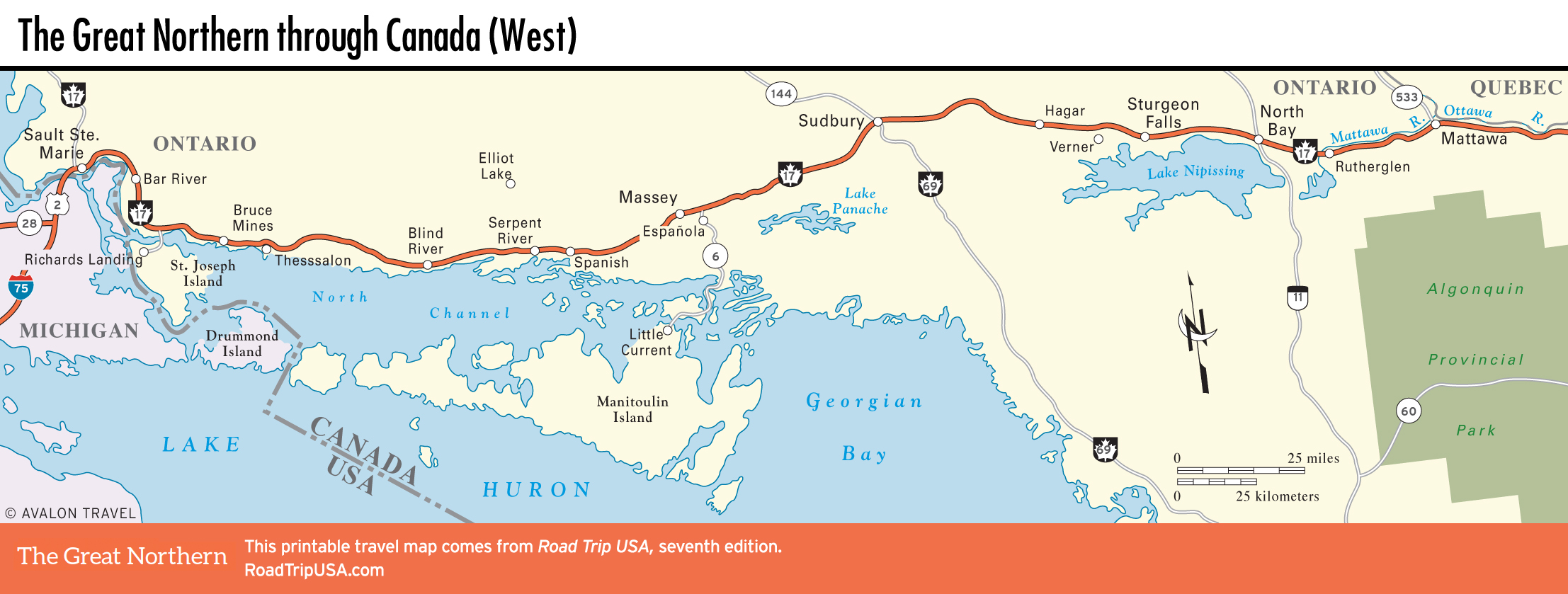
Sault Ste. Marie, Ontario to Manitoulin Island
Sault Ste. Marie, Ontario
Across the busy harbor from Michigan, the “other” Sault Ste. Marie (pop. 73,368) is a much bigger, much grittier, and comparatively depressed Canadian sibling. Fortunately, the main visitor attraction offers a quick escape from all the heavy industry. From the Algoma Central Railway Terminal, well signed downtown, the Agawa Canyon Tour Train (129 Bay St., 705/946-7300 or 800/242-9287, daily, C$100 and up) depart throughout the summer and early fall (fall color season is the prime time to come). These daylong train trips take you north through a roadless wilderness featuring narrow river canyons and spectacular views. An hour and a half stop above the canyon lets you get out and have a picnic or stretch your legs with a walk to a waterfall.
St. Joseph Island
East of Sault Ste. Marie, Hwy-17 winds along Lake Huron’s North Channel waterfront for most of the way to Sudbury. South and east of Bar River, a turnoff heads south to St. Joseph Island, part of the Manitoulin Island chain. The main sight here lies at the island’s south end: Fort St. Joseph National Historic Site. When the fort was built by the British in 1796, it was the westernmost outpost of their Canadian empire. At first the fort protected the fur trade; it then served as a base for attacking the Americans during the War of 1812. The Americans burned the fort in 1814, and the park is built around its scenic remains.
At the island’s north end is the tiny town of Richards Landing; the café at the dock serves good burgers and a variety of Italian-inspired entrées.
Along Lake Huron
The town of Bruce Mines, 12 mi (19.3 km) east of the St. Joseph Island turnoff, was founded in 1846 around some small copper mines. As in the UP, and mining areas all over the world, many of the earliest settlers were unemployed tin and copper miners from Cornwall in England. Two smaller islands offshore from Bruce Mines are home to the pleasant Bruce Bay Cottages and Lighthouse (705/785-3473, C$149 and up).
Following Hwy-17 east along the lakeshore toward Massey, the landscape is generally flat with occasional rocky outcrops. Just west of the settlements of Spanish and Serpent River, you have a great view across the North Channel, an arm of Lake Huron, to Manitoulin Island in the distance.
Massey and Manitoulin Island
Massey, “The Home of Chutes Provincial Park and Lots of Friendly People,” sits at the confluence of the Sauble and Spanish Rivers. The main attraction hereabouts is just north of Hwy-17: Chutes Provincial Park offers swimming, camping, picnicking, and several scenic waterfalls along the Sauble River.
East of Massey 15 mi (25 km), and 42 mi (68 km) west of Sudbury, Hwy-17 intersects with Hwy-6, which heads south toward Manitoulin Island, the world’s largest freshwater island, set in the northern end of Lake Huron. Manitoulin is a popular vacation spot, ringed with picturesque harbors at Meldrum Bay, Providence Bay, and South Baymouth.
Related Travel Map
Related Travel Guides