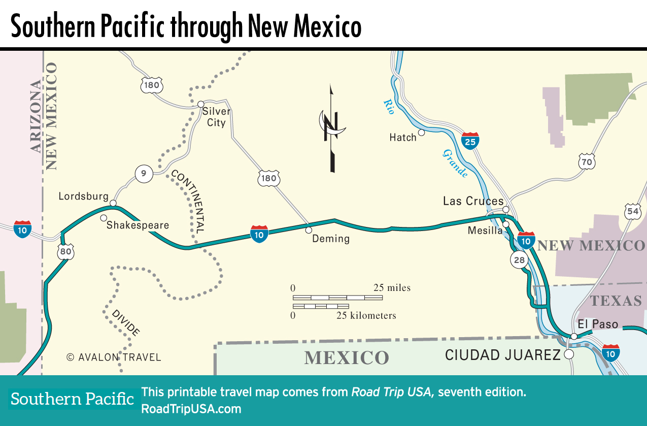
Las Cruces and the Juan de Oñate Trail
Las Cruces
Spreading along the eastern banks of the Rio Grande, at the foot of one of the country’s newest national monuments, the angular Organ Mountains, Las Cruces (pop. 102,926) is the commercial center of a prosperous agricultural and recreational region. Named for a concentration of pioneer grave markers, Las Cruces was first settled by Spanish missionaries but is now a thoroughly modern American-looking place, with all the motels you could want and a youthful vitality made possible by the presence of the large New Mexico State University campus. One place worth searching out is Nellie’s café (1226 W. Hadley St., 575/524-9982), a Mexican restaurant famed for spicy salsas and delicious green chiles rellenos, housed in a little brown box off Valley Boulevard on the northwest edge of downtown.
One more rare treat: West of town along I-10, the Las Cruces rest area is home to a giant statue of the New Mexico state bird, the roadrunner, crafted entirely from recycled material (or what used to be called “trash”).
Mesilla
The historic village of Mesilla, 6 mi (9.6 km) southwest of downtown Las Cruces via Hwy-28, was founded across the Rio Grande on the Mexican side of the border in 1848, after the agreement of the Mexican-American War gave everything north of the river to the United States. Six years later, Mesilla became (legally at least) American again, after the Gadsden Purchase bought the entire nearly 30,000-sq-mi (77,699 sq-m) “Bootheel” region for $10 million.
And not much has changed in the past 160-odd years: Low-slung adobe buildings set around a shady central plaza include the landmark 1851 adobe Basilica of San Albino, an old jail from which Billy the Kid escaped in 1881, and a former Butterfield Stage station that’s now home to the popular restaurant La Posta de Mesilla (575/524-3524, daily lunch and dinner).
Hwy-28: Juan de Oñate Trail
Southeast from Las Cruces and Mesilla, our route dips south across the Texas border to El Paso, then continues on US-180 for some 150 mi (242 km) east before reentering New Mexico at Carlsbad Caverns National Park. For the run to El Paso, you have your choice between I-10 or slower and more scenic Hwy-28, the Juan de Oñate Trail, which avoids the freeway and runs through the pecan groves, pepper fields, and dusty small towns that spread along the west bank of the Rio Grande.
This part of New Mexico is chili country, and there’s no better place to sample the great variety of spicy peppers than at Chope’s Bar and Café (16145 S. Hwy-28, 575/233-3420), an unpretentious cinderblock café along Hwy-28 in La Mesa, roughly midway between Mesilla and El Paso. The house specialty here is chiles rellenos—whole chilies stuffed with cheese and deep-fried.
Map of the Southern Pacific Route through New Mexico
Related Travel Guides