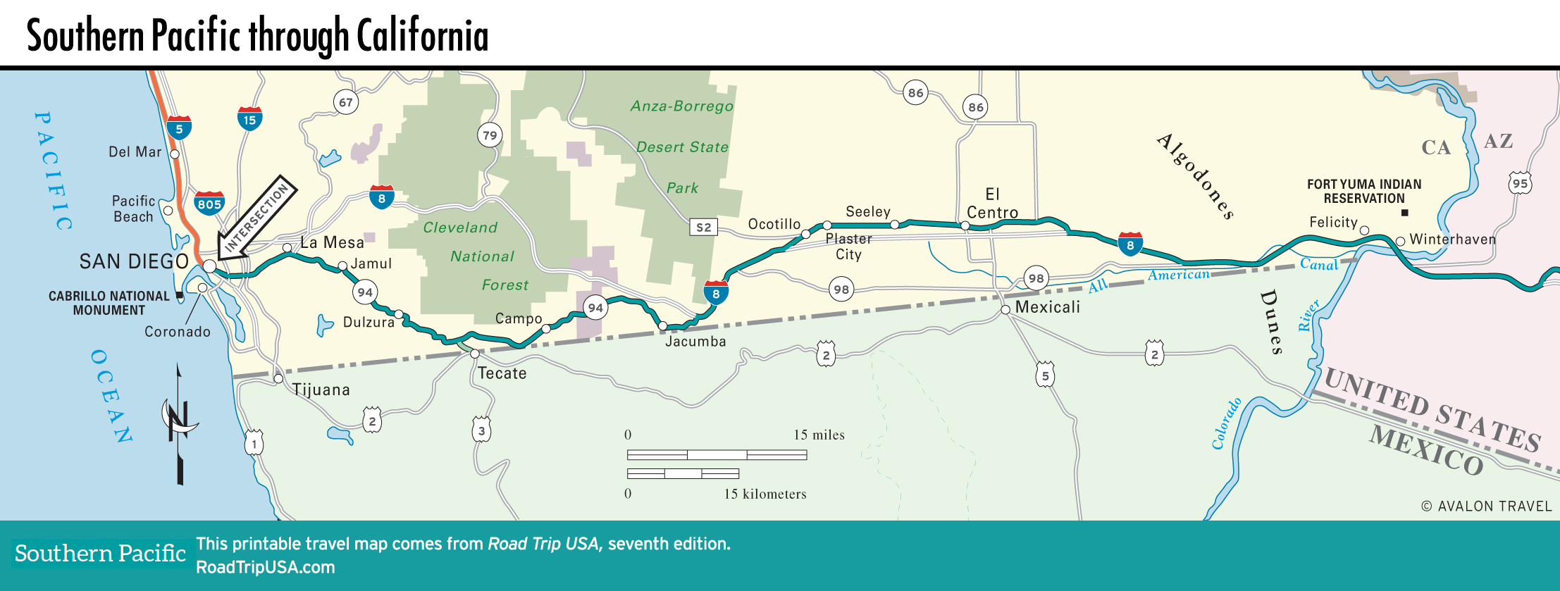
El Centro to Felicity
El Centro
Located some 50 ft (15 m) below sea level, midway across California at the heart of the agricultural Coachella Valley, El Centro (pop. 44,120) was founded in 1906 and has since bloomed into a bustling small city, thanks to irrigation water diverted from the Colorado River. Melons, grapefruit, and dates are the region’s prime agricultural products, along with alfalfa grown to feed the many dairy cows. There’s not a lot here that doesn’t depend on farming.
Though not much of a destination, El Centro is still the best place to break a journey between San Diego and the Arizona border, so fill your gas tank, if nothing else. All the national food and lodging chains are here, along with neon-signed local ones along the I-8 Business Loop. Local character and tasty Mexican food abound at the good Sobe’s (1151 S. 4th St., 760/352-6838), three blocks north of I-8.
Algodones Dunes
In the middle of the southern Mojave Desert, 40 mi (64 km) east of El Centro, a rest area south of the I-8 freeway at the Gray’s Well Road exit gives access to the enticing pink-hued sands of the Algodones Dunes, which stretch on both sides of the freeway for over 40 mi (64 km). The slender dunes, which measure at most 8 mi (12.8 km) wide and reach heights of 200 to 300 ft (61 to 91 m), have been seen in Hollywood movies from Beau Geste to Star Wars and often cover the highway in blowing sandstorms. Though you can amble around on foot, be aware that the dunes themselves are under constant abuse from hordes of motorcycles and dune buggies.
If you’re really, really interested in old highways, you won’t want to miss the reconstructed remnants of a wooden plank road, built across the sands in 1915 and later replaced by the original US-80 highway. Preserved by the dry desert air and arranged to form a 100-ft (31 m) section across the dunes, this fenced-off museum piece is along the south side of I-8, 2 mi (3.2 km) west of the Gray’s Well Road exit. The All-American Canal, which waters the Coachella Valley, snakes alongside the freeway.
Felicity: The Center of the World Pyramid
One of the odder sites in the Southwestern deserts—and competition for this title is pretty fierce—sits just north of the I-8 freeway in the tiny but happily named town of Felicity (pop. 2). Local resident Jacques-André Istel—author of a children’s fairy tale concerning a scholarly fire-breathing dragon named Coe who lives at the center of the world reading fireproof books and eating the nearby Chocolate Mountains—named the “town” after his wife Felicia and somehow convinced France, China, and Imperial County to recognize that Felicity is, legally and officially, the center of the world.
A 21-ft-high (6.4 m) pink terrazzo pyramid stands above the exact spot, which you can visit on regular guided tours (760/572-0100, daily late Nov.-Mar., $3). The fee also buys a certificate saying you’ve stood at “The Official Center of the World.” You can climb a set of stairs that used to belong to the Eiffel Tower and sift through sundry souvenirs in the gift shop.
Map of the Southern Pacific Route through California
Related Travel Guides