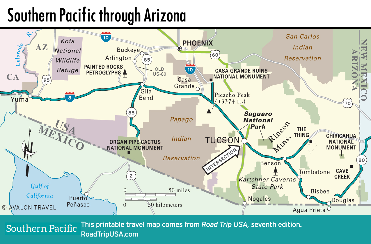
The Border and Cave Creek Canyon
The Border: Douglas and Agua Prieta
Like Bisbee, the border town of Douglas (pop. 15,978) grew up on copper mining, which here lasted until fairly recently: The Phelps-Dodge smelter a mile (1.6 km) west of town was in operation until 1987, processing ores from mines in Bisbee and Mexico. Now most of the economy revolves around the many maquiladora plants in its much larger Mexican neighbor, Agua Prieta (pop. 79,138), which feels surprisingly calm and quiet, considering its border-town location, and its history: It was the site of skirmishes between revolutionary Pancho Villa and the Mexican army.
There’s not a lot to see in either Douglas or Agua Prieta, though Douglas does boast one fabulous attraction: the landmark Gadsden Hotel (1046 G Ave., 520/364-4481, $109 and up). Rebuilt in 1929 after a fire destroyed the 1907 original, the spacious gold-leafed lobby—one of the grandest public spaces in the state—has a pretty Tiffany-style stained-glass mural decorating its mezzanine. The small and basic rooms are bargain-priced. The hotel also has a good Mexican-American restaurant, Casa Segovia, and a popular bar, the Saddle & Spur Tavern, its walls decorated with over 200 cattle brands from area ranches.
Cave Creek Canyon and Chiricahua National Monument
For the 50-odd mi (81 km) between Douglas and the New Mexico state line, old US-80 cuts diagonally across the southeast corner of Arizona, a rugged country of mountains, canyons, and volcanic outcrops rising above sagebrush plains. There’s not much to see along the highway, but to the northwest rise the enticing Pedregosa Mountains, which once served as sanctuary to the Chiricahua Apache people and are now protected as part of the Coronado National Forest. While you can also reach them from the north off I-10, the best access to the mountains from the south is via the aptly named hamlet of Portal, west of old US-80 from the New Mexico state line. In Portal, the Portal Peak Lodge (2358 Rock House Rd., 520/558-2223, $85 and up) is a welcoming oasis, offering peace and quiet, fresh food, and comfortable rooms, plus a handful of nearby cabins.
Above Portal to the west rise the sheer cliffs of Cave Creek Canyon, which writer William Least Heat-Moon described in Blue Highways as “one of the strangest pieces of topography I’ve ever seen,” its pale sandstone walls looking like a sun-bleached twin of Utah’s Zion National Park. Fitting in well with its astounding natural setting, Cave Creek Canyon draws visitors who come to enjoy its superb bird-watching, with more species in one place than you can find anywhere else in the United States, including hummingbirds, bright red cardinals, tanagers, and raptors. Birds and bird watchers flock to Cave Creek Ranch ($135 and up, 520/558-2334).
A narrow but passable (except in winter) 20-mi (32 km) dirt road from Cave Creek climbs over the mountains’ pine-covered 7,975-ft-high (2,431 m) crest, ending up in the west at the foot of intriguing Chiricahua National Monument, a veritable “Wonderland of Rocks” whose contorted shapes were formed out of soft volcanic rhyolite by eons of erosion.
Map of the Southern Pacific Route through Arizona
Related Travel Guides