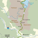
Bitterroot Mountains
South of Hamilton, the serrated peaks and forested foothills of the Bitterroot Mountains close in along US-93 as the valley narrows sharply, the towns shrink in size, and woodlands and campgrounds replace farmlands and commerce along the roadside. Just 17 mi (24 km) south of Hamilton, the pioneer village of Darby has a couple of cafés, a log-cabin public library, and a helpful U.S. Forest Service ranger station (406/821-3913), the best source of information on hiking and camping in the Bitterroots.
South of Darby, US-93 cuts away from the Bitterroot River at the hamlet of Sula, beyond which the highway continues its slow climb up through 6 mi (9.6 km) of subalpine landscape to another of Montana’s many pleasant resorts, Lost Trail Hot Springs (283 Lost Trail Hot Springs Rd., 406/821-3574, $80 and up), open year-round with hot springs pools, an attractive variety of moderately priced rooms and cabins, and a good on-site restaurant. Lost Trail is especially popular with cross-country skiers, who can traverse many miles of nearby trails, including the route followed by Chief Joseph and the Nez Percé in 1877 while fleeing from the U.S. Cavalry.
From Lost Trail Hot Springs, US-93 climbs up to 7,014-foot Lost Trail Pass, which Lewis and Clark crossed in 1805 on their return from the impassable Snake River, and which now marks the border with Idaho. The pass also serves as home to Lost Trail Powder Mountain (406/821-3211, $49), a low-key downhill ski area with 1,800 vertical feet of groomed runs.
Related Travel Guides

Travel Map of the Border to Border Route through Montana