Cahokia Mounds and the Chain of Rocks Bridge
Cahokia Mounds
Old Route 66 followed today’s I-270 around the north side of St. Louis, crossing the Mississippi River on the restored Chain of Rocks Bridge, but one of southern Illinois’s biggest attractions sits directly east of the Gateway Arch, off the I-55/70 freeway at exit 6. Clearly visible to the south side of the interstate, the enigmatic humps of Cahokia Mounds State Historic Site are the remains of a city larger than London was in AD 1250. Some 120 earthen mounds of various sizes were built here by the indigenous Mississippian people while Europe was in the Dark Ages. The largest covers 14 ac (5.6 ha)—more ground than the Great Pyramid of Cheops. But don’t expect the works of the pharaohs: Symmetrical, grass-covered hills sitting in flat, lightly wooded bottomlands are what you’ll find here. The view of the Gateway Arch in distant St. Louis from the 100-ft (31-m) top of Monks Mound lends an odd sense of grandeur to the site. A sophisticated Interpretive Center (618/346-5160, center Wed.-Sun., grounds daily, $7) is a recommended first stop for its exhibits, award-winning multimedia orientation show, and guided and self-guided tours.
The Cahokia Mounds sit in the middle of the American Bottom, a broad floodplain whose gunpowder-black alluvial soils have long been considered among the richest and most productive in the world. However, Charles Dickens was not impressed; after enduring its mud, he wrote in American Notes that the region was an “ill-favored black hollow” which had “no variety but in depth.”
The nearest town to the Cahokia Mounds is Collinsville, a pleasant little place that’s nearly world-famous for its 170-ft-high (52-m) World’s Largest Catsup Bottle, which rises high above Hwy-159 a half-mile (0.8 km) south of Main Street, on the grounds of what used to be the Brooks Catsup Company (800 S. Morrison Ave.). This decorated water tower was constructed in 1949 and restored by the people of Collinsville in 1993; it has since been adopted by Collinsville as a supersize symbol of local pride and perseverance.
Chain of Rocks Bridge
If you have the time and the inclination to stretch your legs and breathe deeply, make your way to the northeast edge of St. Louis, where, instead of following the 75-mph (121 km/h) I-270 freeway, you can cross the Mississippi between Illinois and Missouri on the historic Chain of Rocks Bridge. The bridge has been renovated for use as a mile-long (1.6 km) bike and hiking trail (314/416-9930, dawn-dusk daily), decorated with an array of old gas pumps and signs, just south of the modern I-270 freeway. If you’re driving, the best parking is on the Illinois side of the bridge, but cyclists or energetic walkers can cross the surprisingly narrow bridge and continue all the way to the Gateway Arch in St. Louis, following a 12-mi (19.3-km) Riverfront Trail that snakes between the flood walls, the river, and acres of heavy (and sometimes smelly) industry.
Not quite on the same scale as the Cahokia Mounds, the Chain of Rocks Bridge, or even the Collinsville catsup bottle, the nearby Route 66 town of Mitchell holds one more Route 66 landmark: Luna Café (201 E. Chain of Rocks Rd., 618/931-3152), a one-time casino, speakeasy, and brothel built in 1924 that’s now a pretty seedy but atmospheric bar, north of the I-270 freeway exit 6, along old Route 66.
Related Travel Guides


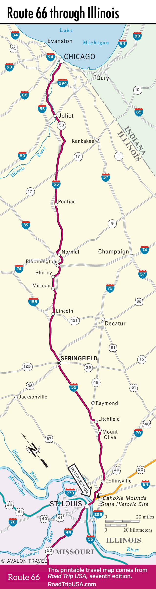
Illinois Travel Map