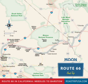
Needles
Founded soon after the Santa Fe Railroad came through in 1883 and named for the group of sharp stone spires that stand near where I-40 crosses the Colorado River from Arizona, Needles (pop. 4,982) is one of the hottest places in the country, with summertime highs hovering between 100°F (38°C) and 120°F (49°C) for months on end.
Though often unbearable in summer, Needles is a popular place with winter snowbirds escaping colder climes; it also has a very rich Route 66 heritage. The stretch of old Route 66 through Needles runs along Broadway, alternating along either side of the freeway. The best place to stop and soak some Route 66 personality is the Wagon Wheel Restaurant (2420 Needles Hwy., 760/326-4305), west of downtown, open all day for good, fresh food, and on Friday nights for all-you-can-eat fish ’n’ chips. The magnificent El Garces Hotel reopened as a transportation facility in 2014.
If you’re set on traveling as much of the old road as possible, another stretch of Route 66 runs west of Needles and north of I-40 through the near-ghost towns of Goffs and Fenner, on a roller coaster of undulating two-lane blacktop, parallel to the railroad tracks.
Related Travel Guides


Maps of California’s Route 66