Sunset Crater
While 90 percent of visitors approach the Grand Canyon from the south, a better and less crowded approach follows US-89 and Hwy-64, climbing up from the Navajo Nation deserts onto the Kaibab Plateau. The views are amazing in any direction— north across the desiccated Colorado Plateau, east across the colorful Painted Desert, west to the forests of the Kaibab Plateau, or south to the angular San Francisco Peaks, including 12,635-ft (3,851-m) Mt. Humphreys, the highest point in Arizona.
This route is somewhat longer than the US-180 route to the Grand Canyon, but in most other ways it’s far superior—not least because it gives access to a huge variety of scenery and historic sites. The first of these, 15 or so mi (24 km) north of Flagstaff and 4 mi (6.4 km) east of US-89, is Sunset Crater Volcano National Monument, home to a 1,000-ft-tall (305-m) black basalt cone tinged with streaks of oranges and reds and capped by a sulfur-yellow rim—hence the name, which was bestowed by explorer John Wesley Powell in 1892. You can hike through the lava field that surrounds the cone, but the cone itself is off limits.
Sunset Crater marks the start of a scenic loop that winds around for some 30 mi (48 km) through neighboring Wupatki National Monument (928/679-2365, daily, $25 per vehicle). The monument protects the remains of a prehistoric Native American community, thought to have been ancestors of the Hopi, who lived here between AD 1100 and 1250 and now inhabit the broad mesas rising to the northeast. Hundreds of ruins—most in fine condition—are spread over the 35,400-ac (14,326-ha) monument. The largest ruin, 100-room Wupatki Ruin, stands near a ceremonial amphitheater and a rare ball court, which may indicate a link with the Maya culture of Central America.
Back on US-89, 25 mi (40 km) north of the north entrance to Wupatki, the crossroads settlement of Cameron stands at the junction with Hwy-64, which heads up (and up) to the east entrance of Grand Canyon National Park. A mile (1.6 km) north of the Hwy-64 junction, along the south bank of the Little Colorado River is historic Cameron Trading Post (800/338-7385, $79 and up), which includes a motel and an RV park. It stands next to an equally historic one-lane suspension bridge, built in 1911 (and now carrying an oil pipeline). Cameron makes a good alternative to Tusayan, in case all the Grand Canyon’s in-park accommodations are full.
From Cameron, Hwy-64 runs west along the Little Colorado River Gorge, which Hopi cosmology considers to be the place where the human race emerged into the present world. This deep canyon leads into the much larger Grand Canyon, while Hwy 64 climbs up the plateau for 32 mi (52 km) to the east entrance of Grand Canyon National Park. Your first overlook is a desert view, where the photogenic 1930s watchtower gives a great taste of the canyon from the highest point on the South Rim.
Related Travel Guides

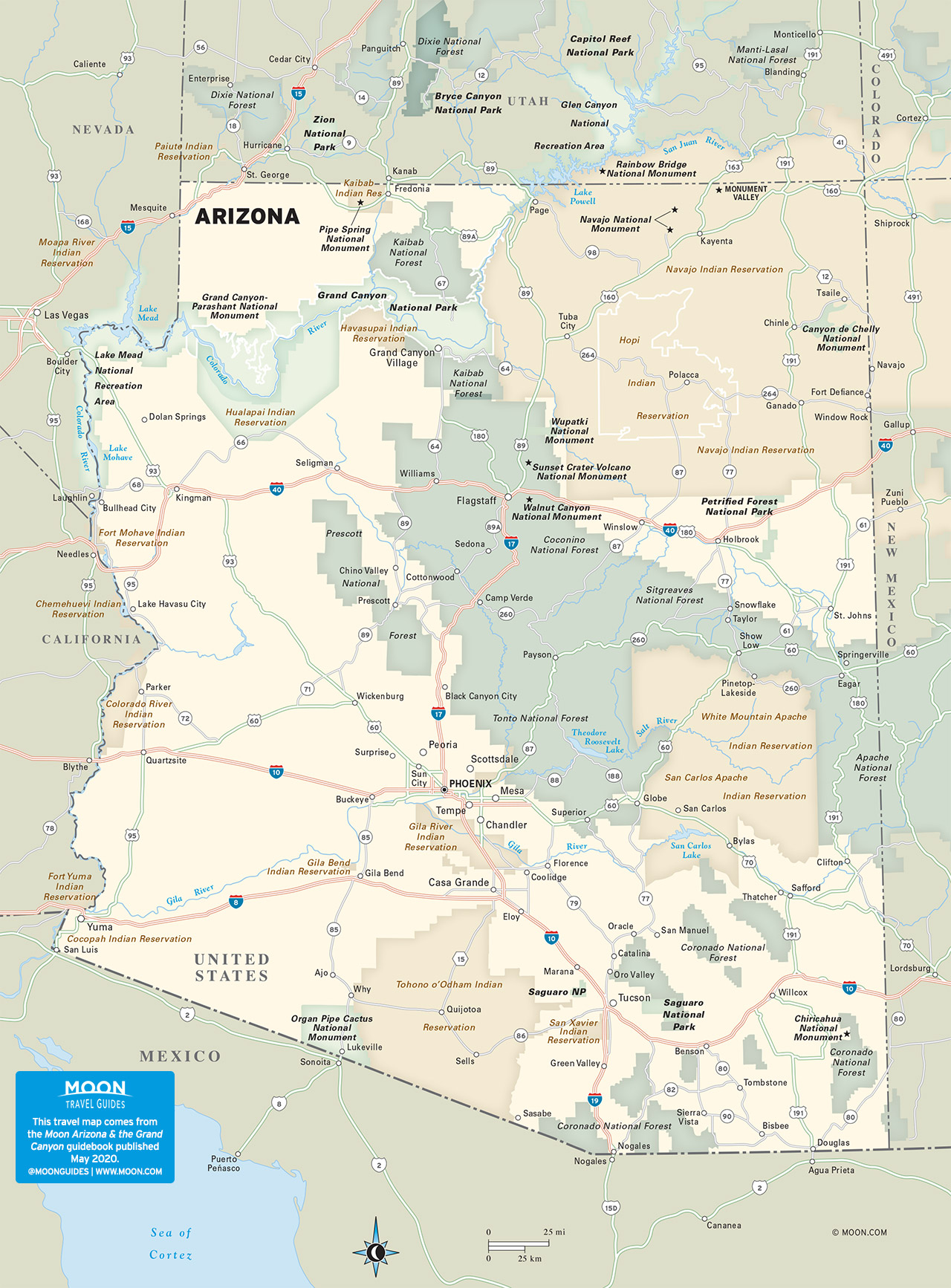
Travel Map of Arizona