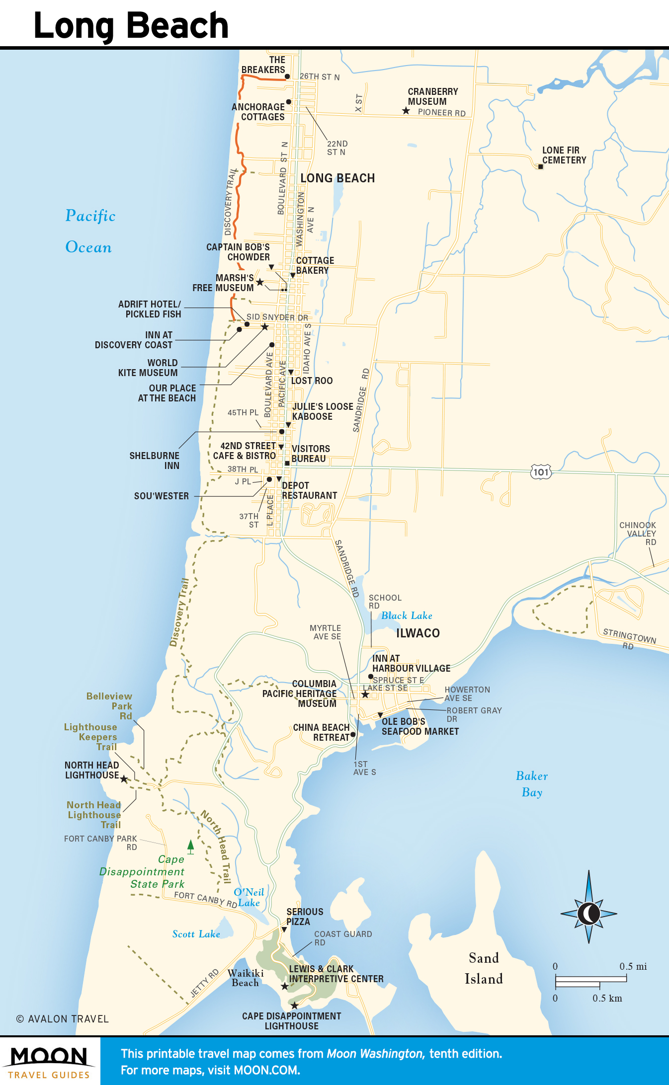
Long Beach Peninsula
On the western side of Willapa Bay, the Long Beach Peninsula stretches for 28 miles of hard-packed sandy beaches along the roiling Pacific Ocean. Away from the few small towns, beaches and breakers abound along here, and you won’t have any problem finding peace and solitude. The center of activity on the Long Beach Peninsula is the town of Long Beach, two miles from US-101, with a wanderable collection of crafts galleries and souvenir shops. A short walk west from “downtown” Long Beach, a wooden boardwalk winds along the coastal dunes, leading to a rare sight: the reconstructed skeleton of a gray whale. Lewis and Clark saw similar bones when they passed by 200-plus years ago, and a Discovery Trail linking Corps of Discovery locations runs from here south to Ilwaco, near the mouth of the Columbia River.
If you can bear to stretch your budget a little, Long Beach is home to one of the coast’s best B&Bs, the historic Shelburne Inn (4415 Pacific Way, 360/642-2442, $84 and up), located in the Seaview neighborhood (Pacific Way is also known as Hwy-103, the main road). The Shelburne Inn also houses a friendly pub. Perhaps most appealing of all: Long Beach is also the home of the nearly-10-foot-in-diameter “World’s Largest Frying Pan,” which sits on a rack across from the one-of-a-kind Marsh’s Free Museum (409 S. Pacific Ave., 360/642-2188), a totally tacky and wonderfully kitsch collection of postcards, peep shows, and old-time arcade games.
The rest of the slender Long Beach Peninsula is quite quiet, dotted with cranberry bogs and historic fishing and oystering towns. Oysterville is the peninsula’s oldest community, with some nifty historic homes dating back to the 1850s. The peninsula comes to an end in the north at Leadbetter Point State Park, a great place for watching gulls, hawks, eagles, and migratory seabirds passing through on the Pacific Flyway.
Travel Map of the Long Beach Peninsula
Related Travel Guides