Wendover and the Ruby Mountains
Wendover
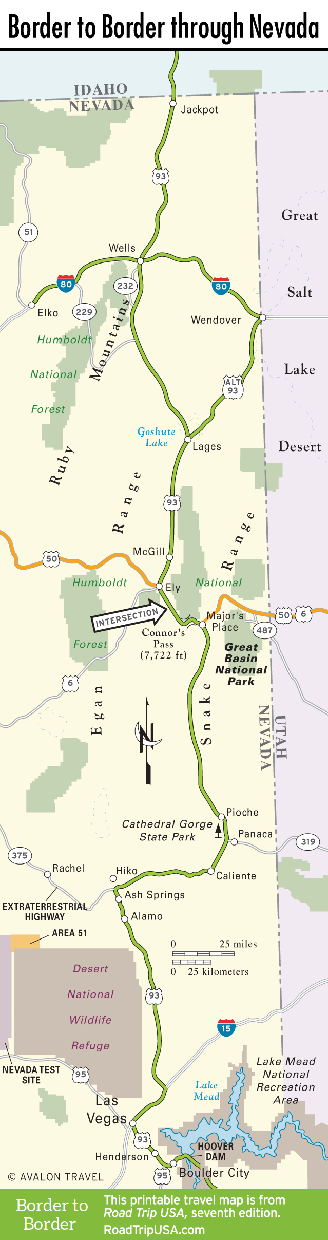
At I-80, US-93 becomes the hypotenuse of an alternate route, which runs for 60 miles southeast to the Utah border at Wendover, then another 60 miles southwest to rejoin the main US-93 at Lages Station. Wendover, like Jackpot, is a bustling border town, with golf course-view subdivisions and at least five major casino-hotels drawing gamblers from Salt Lake City, 120 miles to the east.
Wendover’s other claims to fame include Wendover Will, the more than 60-foot-tall neon cowboy who welcomes you to Nevada along the Utah state line; the Bonneville Salt Flats and speedway, where most of the world’s early land-speed records were set; and Wendover Air Force Base, where in 1945 the crew of the Enola Gay trained to drop an atomic bomb on Japan.
The Ruby Mountains
It’s a long, solitary, 140 miles from Wells to Ely. US-93 shoots down Clover Valley to the southern edge of the East Humboldts, where Hwy-229, a maintained gravel road, cuts off southwest toward the Ruby Mountains, also known as the Nevada Swiss Alps. This is one of Nevada’s most scenic ranges: 80 miles long, with more than a ten peaks over 10,000 feet.
The best access to the Ruby Mountains is 50 miles west of Wells via I-80, through the engaging small city of Elko (pop. 20,279), which enjoys the economic benefits of sitting astride one of North America’s largest deposits of gold. Besides mining gold and maintaining its traditional Basque culture, Elko is home to the Western Folklife Center (501 Railroad St., 775/738-7508), in the old Pioneer Hotel Building, which hosts the popular National Cowboy Poetry Gathering every January.
Eight miles west of town along I-80, history buffs will want to spend some time at the California Trail Interpretive Center (775/738-1849, free), a Bureau of Land Management-run museum tracking the old trails that snaked across the Wild West from the 1840s to the coming of the railroads. For a taste of Wild West hospitality, take advantage of some of the fine family-style Basque restaurants, like the Star Hotel (246 Silver St., 775/738-9925), near the railroad tracks, which is worth the drive for the delicious lamb chops and other dishes. The Star Hotel has been in business for more than 100 years with few changes, so they must be doing something right.
Back on US-93, between Wells and Ely, US-93 bends away from the heart of the Ruby Mountains, running southeast through Steptoe Valley on a marathon drive down an elongated basin, hemmed in by the Schell Creek Range on the east and the Egan Range on the west. The only signs of civilization on this stretch are two roadhouses: one at Lages Station (78 miles south of Wells) and the other at Schellbourne (40 miles north of Ely), where there’s also an old Lincoln Highway marker, all but abandoned in the sagebrush east of US-93.
Related Travel Guides
Travel Map of the Border to Border Route through Nevada