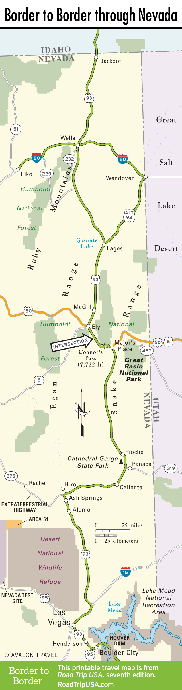
Panaca to Rainbow Canyon
Panaca
Panaca, 11 miles south of Pioche and a mile east of US-93 on Hwy-319, was founded in 1864 by Mormon farmers, attracted to the valley by the plentiful water of Panaca Spring, in what was then a part of Utah. The mining strikes at nearby Bullionville and Pioche disturbed their peace briefly, but Panaca—which has a single gas station-mini mart, plus a school and lots of houses—has a strong sense of tranquility and timelessness rarely felt in the rest of Nevada.
Just west of US-93, two miles north of Panaca, Cathedral Gorge State Park is a mini Grand Canyon of eroded mud. A lake once covered this deep gully, and silt and clay were washed to the bottom by streams and creeks. The lake dried up, exposing the sediments, and erosion (which never sleeps) sculpted them into the fantastic procession of formations you see today. The campground (775/728-4460) here has shade ramadas, flush toilets, and even showers.
Caliente
To Pioche’s mining and Panaca’s farming, Caliente (pop. 1,109), 15 miles south of Panaca, adds railroading. This small town was built around the San Pedro, Los Angeles, and Salt Lake Railroad tracks in the early 1900s, a short while before Las Vegas itself was founded. The Union Pacific Depot was built in 1923 and still serves as the nerve center of Caliente, having been restored to house government offices, a local history museum, an art gallery, and a boxcar collection. If you are interested in precolonial Nevada, the Bureau of Land Management office here has a good free map and guide to the Caliente region’s fantastic array of Native American rock art.
The town supports two gas stations and the Mulls’ Midway Motel (251 N. Spring St., 775/726-3199, $40-80), along US-93, but food offerings are limited.
Newman and Rainbow Canyons
South from Caliente, US-93 bends due west for 43 miles. Newman Canyon, just outside town, has high, sheer, smooth volcanic-tuff walls. You twist and climb out of the canyon to cross the Delamar Range at Oak Springs Summit (elev. 6,247 feet), where the juniper trees are a welcome change from the low desert scrub. Beyond is a short interface zone in which the junipers grow right next to Joshua trees, an indication of the change from Great Basin Desert, which lies to the north, to the front edge of the Mojave Desert, which spreads south and west. Pahroc Summit is next (just under 5,000 feet), then Six Mile Flat, and then Hiko, where Hwy-318 races north to Ely, and Hwy-375 (a.k.a. “The Extraterrestrial Highway”) heads northwest to US-6 and Tonopah.
A nice alternative to US-93 is Hwy-317, south of Caliente through Rainbow Canyon. This is one of Nevada’s most scenic and least-known drives. Colorful high volcanic-tuff cliffs hold one of the state’s preeminent collections of ancient rock art, while railroad trestles, idyllic farms, and ranches line Meadow Wash. The pavement ends after 21 miles, but in dry weather even a rental car can continue 38 miles through Kane Springs Valley to connect back to US-93.
Related Travel Guides
Travel Map of the Border to Border Route through Nevada