McGill to Majors Place
McGill
Tiny McGill (pop. 1,148), 128 miles south of I-80 and 12 miles northeast of Ely, is the classic Nevada company town, its workaday life revolving for the first 50 years of the 20th century around a giant copper smelter. Kennecott Minerals mining company officials lived in the fancy houses around the “Circle” at the top of the hill just below the factory, while workers were housed according to their ethnic origins. The saloon and jail were conveniently built right next door to each other, and steam from the copper furnaces was piped to heat the town’s houses. The company has been gone for more than 30 years, but the layout remains, along with acres of fenced-off brick factory buildings painted with fading signs encouraging workers to behave safely. A few of McGill’s buildings have been converted to current uses, but most are closed and quite forlorn.
One semi-survivor along this short stretch of US-93 is the McGill Drugstore Museum (11 4th St., 775/235-7082 or 775/235-7276, open by appointment or good luck), closed since the 1970s but preserved as an ad hoc museum under the care of the White Pine Public Museum in neighboring Ely. If you can’t arrange a tour, peer in through the windows at a soda fountain and shelves stocked full of Nixon-era merchandise and old uniforms from McGill High School marching bands.
Detour: Bonneville Speedway
Located in the middle of nowhere, west of the Great Salt Lake on the Utah-Nevada border, the vast salt flats of Bonneville cover some 160 square miles. Since the 1930s, Bonneville’s broad, hard, flat, and unobstructed surface has made it a mecca for efforts to set ever-faster land speed records. The earliest speed records were set at Daytona Beach, Florida, but as top speeds increased, racers needed more room to maneuver safely. In 1931, Ab Jenkins set Bonneville’s first world record in his bright red Mormon Meteor, and racers have converged on Bonneville’s 10-mile-long drag strip in pursuit of record-breaking speed ever since. Burt Munro’s motorcycle speed record was set here at Bonneville in 1967, as depicted in the 2005 Anthony Hopkins movie The World’s Fastest Indian.
Craig Breedlove, in his car named Spirit of America, was the first to exceed the 400, 500, and 600 mph marks. In the 1990s, problems with water from nearby mining operations dissolving the salt made Bonneville less than ideal, so racers like Richard Noble, whose team set the current record of 763 mph in 1997, opted for the Black Rock Desert, 110 miles north of Reno, Nevada. In recent years the salt flats have been restored to their historical thickness and size, and once again, hundreds of thrill-seekers descend on Bonneville every August for “Speed Week,” racing their vintage cars, hot rods, and motorbikes in a series of time trials.
Connors Pass
Southeast of Ely, US-93, spliced together with US-50 and US-6 into a single two-lane highway, continues for 23 miles before crossing the narrow waist of the Schell Creek at Connors Pass (elev. 7,722 feet), one of only two areas of Nevada located above the tree line. As you ascend toward the pass, the air cools and freshens, the single-leaf piñon and Utah juniper appear and thicken, and, cresting the summit, the mighty Snake Range, including 13,061-foot Wheeler Peak in Great Basin National Park, comes into view.
Majors Place
At Majors Place (where there’s a dusty old roadhouse with gas, beer, burgers, and a pool table), US-93 splits off from US-50 and US-6, the latter two heading east toward Utah, while US-93 cuts south, heading 80 long solitary miles to the next contact with humans at Pioche. Once again, the highway rolls along, ushered on its way by the Schell Creek, Fairview, Bristol, and Highland Ranges on the west, and the Snake and Wilson Creek Ranges on the east.
Related Travel Guides
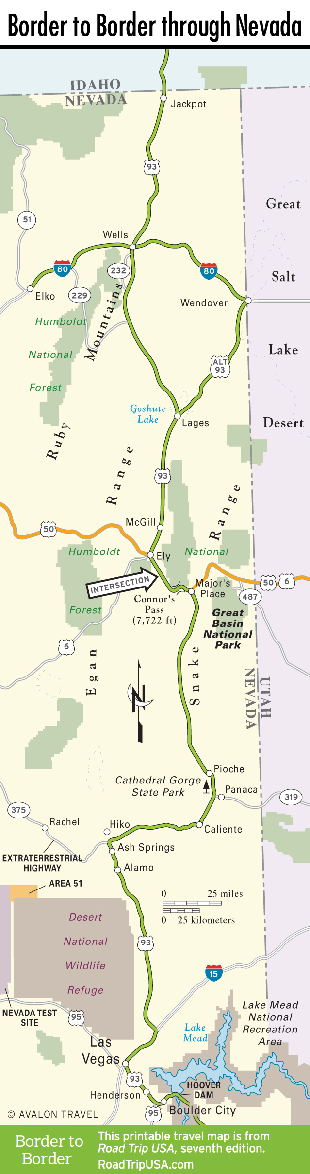
Travel Map of the Border to Border Route through Nevada