Salmon River
Salmon River: North Fork
Beginning at the Montana border, atop Lost Trail Pass, US-93 winds steeply downhill through the 4.3-million-acre Salmon-Challis National Forest. Another 25 miles south of the pass, US-93 passes by the village of North Fork—where the friendly folks at the North Fork General Store (208/865-7001) run a combination café, motel, and post office that has everything a traveler could want, from great pies to an RV park. Here US-93 crosses the Salmon River, which is often called the “River of No Return,” because without a jet boat to help you along, it is navigable only in a downstream direction. Running swiftly for nearly 300 miles west through one of the most extensive wilderness areas left in the lower 48 states, the Salmon River has carved one of the deepest gorges in North America, a full 1,000 feet deeper than the Grand Canyon.
From North Fork, a paved road leads 18 miles west along the riverside to the tiny hamlet of Shoup, beyond which a number of rough roads and hiking trails lead to ghost towns and the Frank Church-River of No Return Wilderness, deep in the rugged mountains.
Salmon
Surrounded by ranch lands in a broad valley between the Bitterroot and Yellowjacket Mountains, Salmon (pop. 3,041) is a picturesque place that has turned increasingly to tourism and outdoor recreation as its timber and ranching industries have faded. Rafting and fishing guides will take you out into the wilds, so Salmon is both a good base for exploring the surrounding scenery and a destination in itself. Main Street, which US-93 follows through town, has a good variety of places to eat, including the Salmon River Coffee Shop (606 Main St., 208/756-3521). There are some motels along US-93, but the best place to stay is the Syringa Lodge (13 Gott Lane, 208/756-4424), a log-cabin B&B about a mile west of Main Street, offering panoramic views, reasonable rates, and a warm welcome.
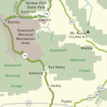
Salmon River Gorge
South of Salmon, US-93 continues beside the Salmon River, climbing slowly through a landscape that alternates from open meadows to sheer canyons. Nearly 100 miles later, the route arrives at the river’s headwaters high up in the Sawtooth Mountains. Apart from a few cottonwoods, there are few trees and no real towns along this stretch of US-93, and traffic still has to stop for the occasional cattle drive. It’s a pretty drive, and you can stop almost anywhere for a quick walk or picnic along the river. The appearance of the Salmon River canyon varies tremendously, but for most of the way it is dry and brown—a real shock compared to the dense green forests of Montana, just an hour north.
Related Travel Guides

Map of the Border to Border Route through Idaho