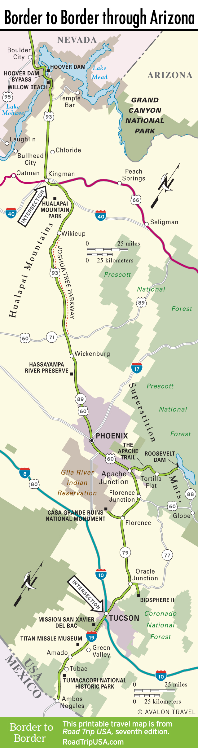
Superstition Mountains and the Apache Trail
East of Phoenix, US-60 runs as a four-lane freeway through suburban Tempe and Mesa, but the sprawl fades as you approach the angular Superstition Mountains, some 40 miles east of downtown. Protected within the massive Tonto National Forest, this area of volcanic crags, desert cactus, and ponderosa pines is best seen by traveling along Hwy-88, the scenic Apache Trail, which winds along the Salt River, the region’s lifeblood. Named for the Native Americans who lived in the area a century ago, and now an official National Scenic Byway, the Apache Trail is a 45-mile loop, but even a short trip along it will take you far away from the fast lane.
A mere seven miles north of US-60, the Phoenix suburbs give way to the wild desert of Lost Dutchman State Park (480/982-4485, $3 per person or bike, $7 per car), named for a legendary gold mine located nearby. Two miles farther is the overlook for the 4,535-foot phallus of Weaver’s Needle, beyond which the road passes several reservoirs before reaching the entertaining tourist-trap hamlet of Tortilla Flat (pop. 6), 18 miles from US-60 and named after the Steinbeck novella—which has nothing to do with Arizona, but who cares?
Beyond Tortilla Flat, the road turns to dirt and twists and turns through spectacular desert country for the next 27 miles to Roosevelt Dam, then heads southeast to rejoin US-60 near Globe, at the western edge of the San Carlos Apache Indian Reservation, 87 miles east of Phoenix.
In springtime in particular, another great attraction of the Apache Trail region is the Boyce Thompson Arboretum State Park (520/689-2811, daily, $12.50), the state’s oldest and largest botanical exhibit, covering 323 acres with a full array of Sonora Desert cactus and wildflowers. The arboretum is 27 miles west of Globe, right on US-60, near the copper-mining town of Superior.
Related Travel Guides


Travel Map of the Border to Border Route Through Arizona