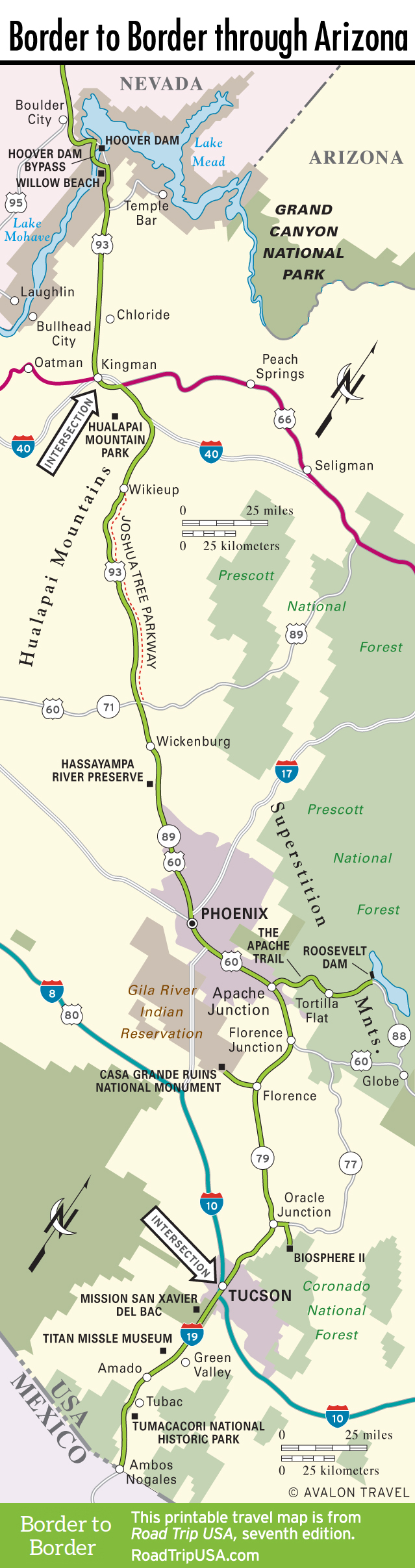
Lake Mead National Recreation Area to Joshua Forest Parkway
Lake Mead National Recreation Area
Most people come from the Las Vegas area to visit Lake Mead, which covers some 160,000 acres and includes over 750 miles of shoreline, on the extensively developed Nevada side. In contrast, the only access on the Arizona side is from Temple Bar, 19 miles south of Hoover Dam, then another 27 miles northeast on a good paved road. Here you’ll find a small marina (928/767-3211) with boat rentals and lodging.
Stretching to both sides of Hoover Dam, the Lake Mead National Recreation Area also incorporates the smaller Lake Mohave, clearly visible from US-93 and accessible at Willow Beach on the Colorado River, 17 miles south of Hoover Dam and 4 miles west of US-93.
Chloride
Marked by a big “C” inscribed in the hillside above it, the near-ghost town of Chloride (pop. 352), which is 53 miles south of Hoover Dam and 15 miles north of Kingman, then 4 miles east of the highway on a well-marked paved road, is the oldest and among the most evocative former mining camps in Arizona. Following the discovery of silver here in the 1860s, mining activities continued through the 1940s; the town is now preserved by its dedicated residents.
A couple of stores and a restaurant still cling to life, and occasional festivals and flea markets draw sizable crowds of visitors. Mostly what there is to see are the odd bits of “folk art” so often found in the American desert: strange front-yard sculptures made of rusting metal and odd bits of junk, plus comical tributes to the mythology of the Wild West, like a fake “Boot Hill” cemetery with laconic epitaphs and hand-painted signs playing up the apocryphal legacy of the local “Hangin’ Judge” Jim Beam.
Joshua Forest Parkway
East from Kingman, US-93 follows I-40 for over 20 miles before turning south, back onto two-lane US-93. Because it’s the main route between Phoenix and Las Vegas, US-93 can be busy, and in many places the roadway is being improved and expanded to handle all the trucks and other traffic, but it’s one of the great (and least hyped) drives in the desert Southwest. The scenery improves as you head south from I-40, with chocolate-brown boulders and varnished granite cliffs rising to form impressive canyons above forests of saguaro cactus, Joshua trees, and abundant spring wildflowers. The only real “place” along this stretch of US-93 is a wide spot in the road known as Wikieup, 30 miles south of I-40, with a pair of gas stations and trading posts.
Between Wikieup and Wickenburg, the 75-odd miles of US-93 are known as the Joshua Forest Parkway because the road passes through one of the world’s densest concentrations of these odd trees, which were named by Mormon pioneers. Anthropomorphic, multilimbed members of the lily family, and found only here in western Arizona and in southern California, Joshua trees can live to 200 years old and reach 50 feet tall.
Related Travel Guides

Travel Map of the Border to Border Route Through Arizona