Arizona
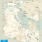
Coming into Arizona across the top of Hoover Dam, US-93 cuts southeast across the length, and half the breadth, of the state, covering nearly 500 miles of desiccated desert.
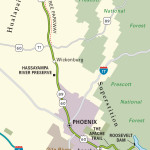
Starting at the Nevada border, US-93 makes a diagonal beeline toward the old Route 66 town of Kingman, one of the few watering holes in Arizona’s northwest quarter. Joshua trees and ghost towns far outnumber gas stations in this part of the state, so fill up before setting off into these great wide-open spaces. From Kingman, the route cuts south across another huge stretch of desert, passing through the dude-ranch resort town of Wickenburg.
In the middle of Arizona spreads Phoenix, the state’s capital and largest city. From this sprawling megalopolis, our route bends east into the mountains, following back roads past the otherworldly Biosphere 2 “space station” before hitting Tucson, another hugely horizontal city. South of here you’ll enjoy the most feature-packed part of the trip, passing by the historic Spanish colonial communities of Tubac and Tumacácori before winding up at the enjoyable twin border towns of Ambos Nogales.
Related Travel Guides


Travel Maps of the Border to Border Route in Arizona