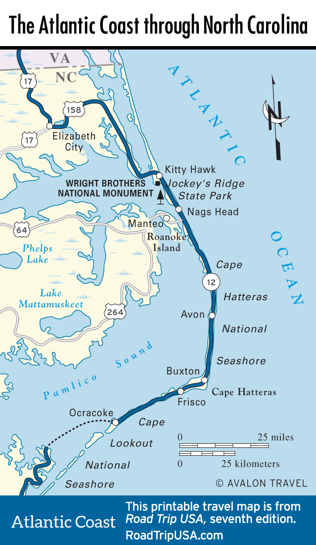
Kitty Hawk to Nags Head
Kitty Hawk: The Wright Brothers National Memorial
Alternately known as Killy Hauk, Kitty Hock, and Killy Honk before its current name came into general use, Kitty Hawk to most people means one thing: the Wright brothers’ first powered airplane flight more than a century ago, on December 17, 1903. Lured by the steady winds that blow in from the Atlantic and by the high sand dunes that cover the shore, Wilbur and Orville Wright first came to the Outer Banks in 1900 and returned every year thereafter with prototype kites and gliders built out of bicycle parts, which they fine-tuned to create the world’s first airplane. Their tale is truly one of the great adventure and success stories of the modern age, and the site of their experiments has been preserved as the Wright Brothers National Memorial ($10 adults). First stop is the visitors center (252/473-2111, daily) which includes a number of exhibits tracing the history of human efforts to fly. There are daily ranger-led talks and tours that visit the site of the first flight.
The most affecting aspect of the memorial is the unchanged site where the brothers first flew. Each of the first four flights is marked by stones set on the grassy field. The first flight, with Orville at the controls flying into a 25-mph (40 km/h) headwind, lasted 12 seconds and covered just 120 ft (36 m)—barely more than a brisk walking pace. The 90-ft-high (27.4m) sand dune where Wilbur and Orville first took to the air has been planted over with grasses to keep it from blowing away. Paths climb to the top of the dune, where a 60-ft (18.3 m) wing-shaped granite pylon is inscribed with these words:
In commemoration of the conquest of the air by the brothers Wilbur and Orville Wright. Conceived by genius, achieved by dauntless resolution and unconquerable faith.
Jockey’s Ridge State Park
The windswept 110-ft-high (30.5-m) twin sand dunes of Jockey’s Ridge State Park (252/441-7132, daily, free) tower over US-158 between Kitty Hawk and Nags Head. The highest sand dunes on the East Coast, Jockey’s Ridge barely survived being bulldozed in the 1970s to form yet another Outer Banks resort; it’s now one of the prime hang-gliding spots in the country—remember the Wright brothers! Jockey’s Ridge is also a nice place to wander the short boardwalk nature trail that points out the diverse plants and animals of the dune community. You may want to take your shoes off and scamper around the sands barefoot. If you feel especially daring, Kitty Hawk Kites Hang Gliding School (252/441-2426, $99 and up) in the park at milepost 12 dubs itself the “World’s Largest Hang-Gliding School” and offers equipment rentals to certified pilots and lessons to those of all experience levels, plus anything else you might need to make the most of your time here.
Nags Head
The towns of the northern Outer Banks overlap each other so much it can be hard to tell you are in Nags Head, 9 mi (14.5 km) south of Kitty Hawk. One of the oldest and most popular resorts in the region, Nags Head also offers the widest range of visitor facilities. Good places to spend a night or two include a beachfront roadside classic at milepost 16.5: the historic Sea Foam Motel (7111 S. Virginia Dare Trail, 252/441-7320, $85 and up), one of the last surviving 1940s motels on the Outer Banks. The pine-paneled walls, vivid tiles, and slamming screen doors will take you back to a simpler time. Nearby, the even more atmospheric First Colony Inn (6715 S. Croatan Hwy., 252/441-2343 or 800/368-9390, $110 and up), along US-158 at milepost 16, was moved from its valuable oceanfront location to the middle of the island, but it still offers oodles of old-fashioned charm along with a delicious breakfast and afternoon tea.
One more long-standing local landmark, Sam & Omie’s (7228 S. Virginia Dare Trail, 252/441-7366, closed for a few weeks in winter), near the east end of US-64, has featured inexpensive but well-prepared family fare, three meals a day plus a full bar, for 80 years.
Related Travel Guides
Map of the Atlantic Coast Route through North Carolina