Maryland
The Appalchian Trail through Maryland
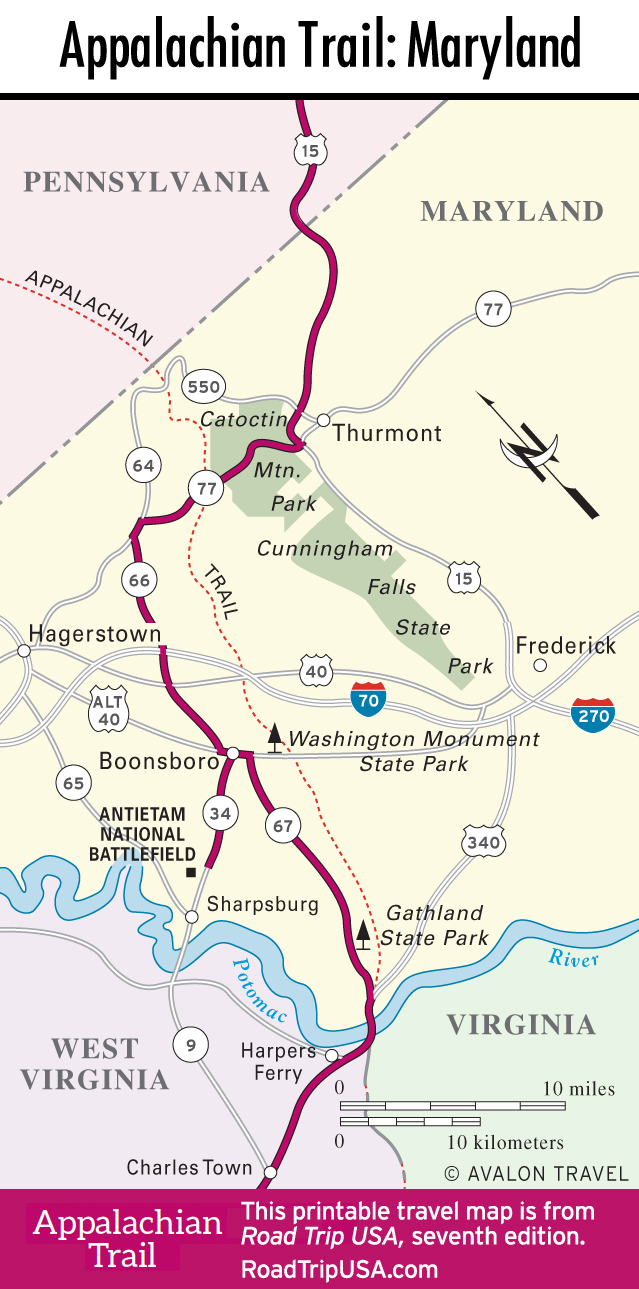
Crossing the Mason-Dixon Line from Gettysburg into Maryland on US-15, our route veers west into the Appalachian foothills of Catoctin Mountain Park, site of the presidential retreat Camp David.
The landscape here is quite rugged, and signs of life few and far between—an oasis of peace and quiet, under an hour by road from Baltimore or Washington DC. Winding south through the mountains of the Maryland Panhandle (the thin strip of land that stretches for some 75 miles between Pennsylvania and West Virginia), this route again meets the hikers’ Appalachian Trail, then detours to visit the battlefield of Antietam, the well-preserved site of the worst carnage of the Civil War.
Catoctin Mountain Park: Camp David
US-15 continues south from Gettysburg across the Maryland border, and there’s little to stop for until Thurmont (pop. 6,752), “Gateway to the Mountains.” The green expanse of Catoctin Mountain Park, fully recovered after previous centuries of logging activity, protects some 5,810 acres of hardwood forest, a handful of 1,500-foot peaks, and the presidential retreat at Camp David, hidden away in the woods and strictly off-limits to visitors (for security reasons, Camp David doesn’t even appear on park maps). The Catoctin park visitors center (301/663-9388, daily) along Hwy-77 a little more than two miles west of US-15 provides information on cabins, camping, and maps of the many hiking trails, including a short trail from the visitors center to the preserved remains of the Blue Blazes whiskey still.
Spreading along the south side of Hwy-77, Maryland-run Cunningham Falls State Park offers more natural scenery and a pleasant swimming area in Hunting Creek Lake. There’s a snack bar and boats for rent, and a half-mile trail leads to the eponymous cascade.
Washington Monument State Park
From Catoctin Mountain Park, our route heads south on undivided Hwy-6 and two-lane Hwy-17 along the hikers’ Appalachian Trail, winding up at Washington Monument State Park between the I-70 freeway and the small town of Boonsboro. A 30-foot-tall bottle-shaped mound dedicated to the memory of George Washington stands at the center of the park; Boonsboro citizens completed the monument in 1827, making it the oldest memorial honoring the first U.S. president.
Atop a hill south of the park, across an old alignment of the National Road (US-40), the Old South Mountain Inn (301/432-6155, dinner Wed.-Fri., dinner Sat., brunch and dinner Sun.) opened as a tavern in 1732.
Antietam National Battlefield
Between Boonsboro and the Potomac River, which forms Maryland’s border with West Virginia, Antietam National Battlefield preserves the hallowed ground where over 23,000 men were killed or wounded on the bloodiest single day of the Civil War—September 17, 1862. Atop a shallow hill at the middle of the park, a scant mile north of Sharpsburg off Hwy-65, the visitors center (301/432-5124, daily, $10 per car) offers a film, museum exhibits, and interpretive programs that put the battle into military and political context. Though there was no clear winner, Antietam is said to have convinced Lincoln to issue the Emancipation Proclamation, officially freeing enslaved people in Confederate states and effectively putting an end to British support for the southern side.
Atop a shallow hill at the middle of the park, north of Sharpsburg off Hwy-65, is the visitors center (301/432-5124, daily, $10 per person, closed for renovations 2020-2022).
Related Maryland Travel Guides


Maryland Travel Map