Connecticut
Appalachian Trail through Connecticut
Anyone who drives its interstates will appreciate why Connecticut enjoys a solid reputation among New Englanders as “the drive-through state.” The high-speed route between Boston and New York City, I-95, is something endured rather than enjoyed, but our route through the scenic northwest corner is as different from the coastal megalopolis as a tulip is from a truck tire.
Like the neighboring Berkshires, Connecticut’s Litchfield Hills are a traditional retreat for discerning city dwellers. The area is rich in forests, farms, and picturesque little towns laden with antiques and great restaurants. Fast food and discount shopping are as alien to this landscape as affordability, so if your purse strings are tight, you’ll want to keep moving; otherwise, linger a while and enjoy some of the rural charm so prized by those people you might see on the cover of Business Week.
North Canaan and Salisbury
Crossing into Connecticut from the north on US-7, the first thing that will catch your eye is the stainless-steel siding of Collin’s Diner (53 Main St., 860/824-7040) in North Canaan. A classic 1940s prefab O’Mahony diner, Collin’s has all the usual diner standards, and its big parking lot (shared with the neighboring historic railroad depot) is frequently full of equally classic cars, whose owners congregate here on summer afternoons. The rest of North Canaan is anything but prissy, a refreshing change of pace from the overly tidy tourist towns that dominate the surrounding region.
From Canaan, US-44 winds east toward Hartford, stopping after 12 mi (19.3 km) at another gem of a small town, Norfolk; if any town has capitalized on being far removed from trading floors and board meetings, it’s this one. With three public parks and the largest nonprofit-owned and operated forest in the state, Norfolk has considered its sheer scenic beauty a stock-in-trade for nearly a century. The town green is worth the drive so that you can see the folksy road sign that points the way with pictures of rabbits and other cute creatures.
After extensive touring around New England, you risk taking white columns, wide porches, picket fences, and the obligatory Congregational steeple for granted.
West Cornwall
Rivers are consistently some of the most attractive driving companions you could ask for, a fact proven once again as US-7 rejoins the Housatonic River east of Lime Rock. The highway’s scenic miles are further enhanced by the sudden appearance of a barn-red covered bridge, in service since 1864. This is the kind of place that would tar and feather the first vinyl-siding salesperson to walk into town, lest harm befall its antiquarian bookshop or other clapboard buildings bearing signs from previous commercial lives.
South of town in Sharon, Housatonic Meadows State Park (860/927-3238) offers riverside camping, perfectly situated for anyone considering a canoe or kayak rental from nearby Clarke Outdoors (860/672-6365, canoe trips $50 Mon.-Fri., $60 Sat.-Sun. for two people), on US-7 a mile south of that covered bridge. Clarke’s 10-mile (16-km) and 6-mile (9.6-km) canoe trips include a boat, life vests, and all the gear, plus van shuttles and hot showers. Remember to bring bug repellent if you’re planning to spend time near the water.
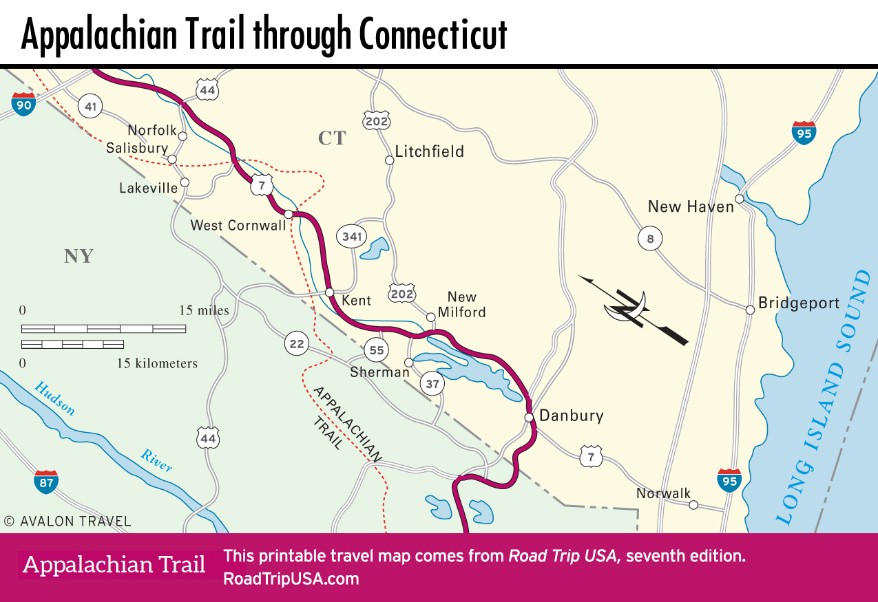
Housatonic Meadows State Park also includes a short 2.4-mi (3.9-km) round-trip trail up 1,160-ft (354-m) Pine Knob, which offers fine views from its summit.South of the park boundary, the hikers’ Appalachian Trail crosses US-4 near the hamlet of Cornwall Bridge, then runs alongside the river for some 6 mi (9.6 km), the longest riverside stretch on the entire trail.
Kent
Like many of its Litchfield-area neighbors, Kent (pop. 2,979) had a thriving iron industry until competition from larger Pennsylvania mines—with better access to post-Civil War markets—forced the local furnace to close. Now it’s a bustling upscale market town, its main street (US-7) lined with antiques shops, galleries, and boutiques that have replaced blacksmith shops and wheelwrights. The area’s transition from industry to leisure is implicit in the unusual displays inside the Eric Sloane Museum (860/927-3849, 10am-4pm Fri.-Sun. summer, $8), located along US-7, near the ruins of an early American iron foundry.
Kent Falls State Park, along US-7 about 4 mi (6.4 km) north of the museum, is a nice place to take a break from behind the wheel. Along with the namesake cascade, which is most impressive after a rain, the park includes a short path through dense woods.
Beginning in the south of Kent, and parallel to US-7 for about 4 mi (6.4 km) along the west bank of the Housatonic River, Schaghticoke Road is a slower, much more scenic route that gives an up-close look at the rugged geology beneath the trees. The route crosses the Schaghticoke Reservation and passes an old Native American cemetery before rejoining US-7 via a covered bridge on Bulls Bridge Road, 3 mi (4.8 km) north of Gaylordsville.
The Appalachian Trail crosses the New York state line near Bull’s Bridge, south of Kent, and so should you, making your way west to Route 22 or the Taconic State Parkway if you want to enjoy a landscape that offers more fields and trees than guardrails and parking lots. Technically speaking, there’s still a large swath of New England between New York and New Milford, but most of this has more in common with the Indianapolis beltway than with the Vermont countryside.
Related Connecticut Travel Guides